
El Born self-guided walking tour · 75 min · map
El Born on foot: from the 1714 graveyard to the Ciutadella
El Born is the lower part of La Ribera, the old seafront quarter east of the Gothic Quarter. This walk starts beside Santa Maria del Mar and follows the neighbourhood's story: the graveyard of 1714, a street of merchant palaces, a market, a concert hall, and a park built where a fortress stood.
La Ribera grew outside the Roman walls from the 11th century, around the monastery of Sant Pere de les Puel·les and the church of Santa Maria del Mar. Its street names still record the trades that crowded in when sea trade boomed in the 13th century: Espaseria, Mirallers, Agullers. The good times lasted until Mediterranean trade fell away in the 16th century. Then, after 1714, Philip V pulled down half the quarter to build a fortress. The area came back to life when the Born market opened in 1876, and the lower part of La Ribera is still named El Born after it. In the early 20th century Via Laietana was cut through, demolishing 2,199 homes and splitting the old town in two: the Gothic Quarter on one side, Sant Pere, Santa Caterina and La Ribera on the other.
If you have walked our Gothic Quarter route, this one starts where it ends.
- Start
- Jaume I metro (L4), on Via Laietana
- Finish
- Castell dels Tres Dragons, Parc de la Ciutadella, about 650 m from Arc de Triomf metro (L1)
- Distance
- 2.6 km, one way
- Time
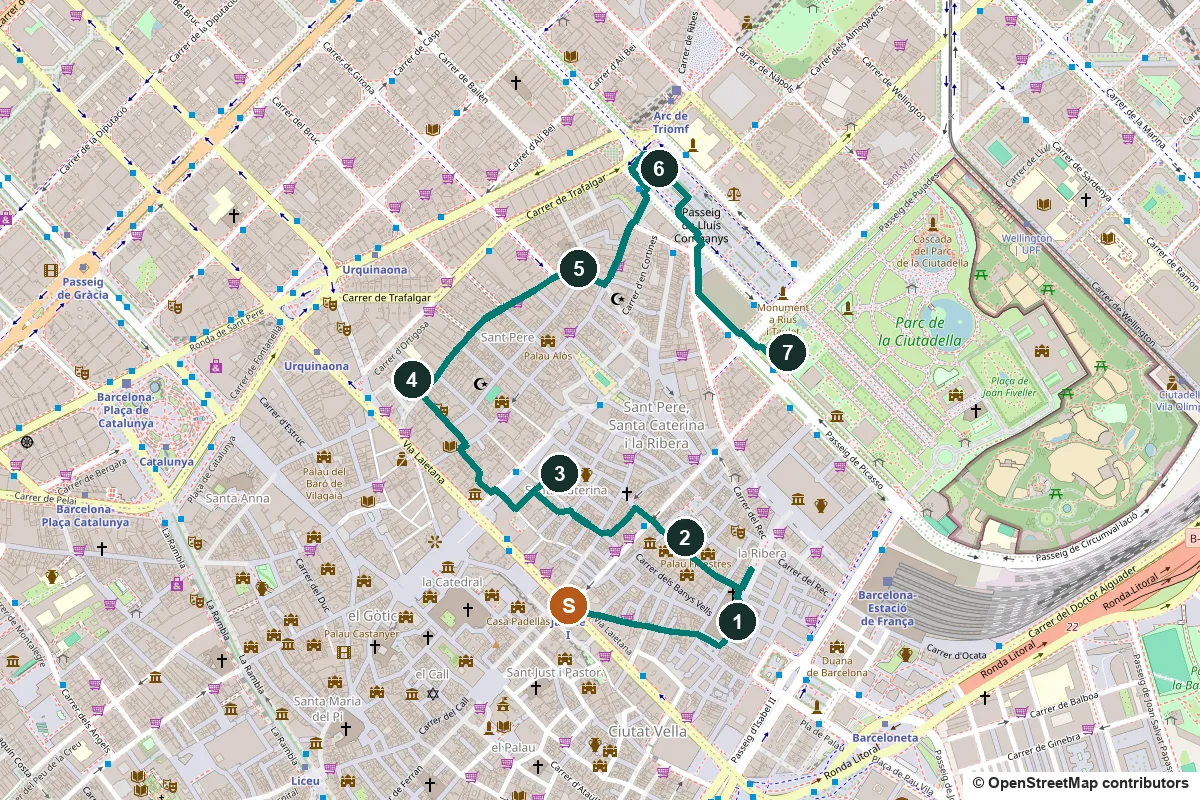
- About 75 minutes: 35 min walking and 7 stops
Terrain, water, toilets and a shorter version ↓
The stops
-
Fossar de les Moreres, the graveyard of 1714
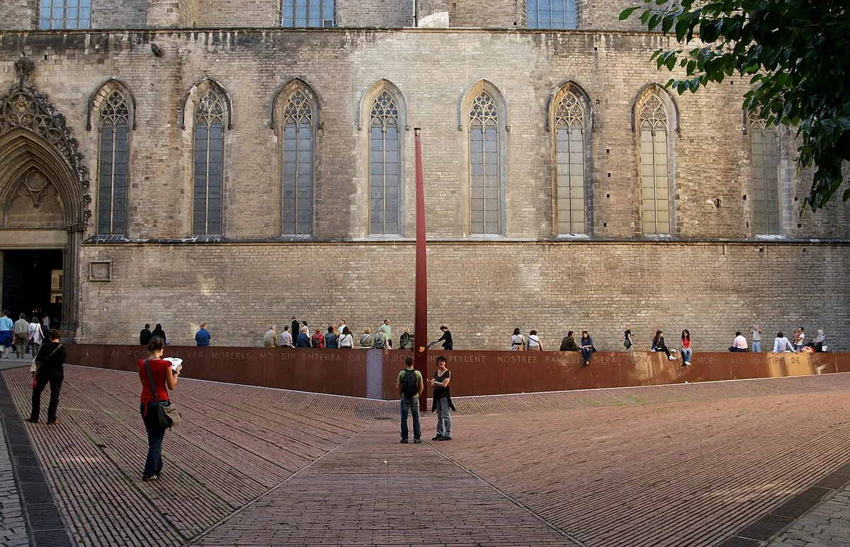
The memorial against the side of Santa Maria del Mar. Photo: böhringer friedrich, CC BY-SA 2.5, via Wikimedia Commons (resized). Walk down Carrer de l'Argenteria to Santa Maria del Mar (a full stop on our Gothic Quarter walk) and along the church's side to a square of red brick that dips into a triangle in the middle. This was the parish graveyard. La Ribera was the last part of the city to hold out in the siege that ended on 11 September 1714, and its defenders were buried here. The 30-metre bench facing the church is red granite from the Soviet Union, the same stone as Lenin's mausoleum. Its inscription reads: "In the Fossar de les Moreres no traitor is buried; even as we lose our flags, it will be the urn of honour. To the martyrs of 1714." The curved column with a flame, leaning towards the church, is by Albert Viaplana.
More history
In the Middle Ages the parish had two burial grounds: the main one in front of the church, and a smaller one, the fossar de les moreres (mulberry graveyard), along its side. The graveyard was closed and hidden in 1802 for a royal visit by Charles IV, and in 1816 the captain general ordered every parish graveyard in Barcelona paved over.
Interest returned in the 19th century with a poem by Frederic Soler, Pitarra, about a gravedigger burying the defenders of 1714 who refuses to bury a soldier of the besieging army: his own son. People began to mark 11 September here from about 1870, and in 1915 two nationalist groups put up a marble plaque at the back of the square with the poem's first lines.
By 1978 the square was a car park, and a campaign began to restore it. The present square follows a 1989 design by the architect Carme Fiol. The Generalitat declared it a national cultural asset in 1999, the memorial was built in 2001, and since April 2002 the Memorial 1714 association has laid flowers with a Catalan flag at the flame every Sunday at noon.
Source: Viquipèdia, Fossar de les Moreres.
-
Passeig del Born and Carrer de Montcada, the merchants' street
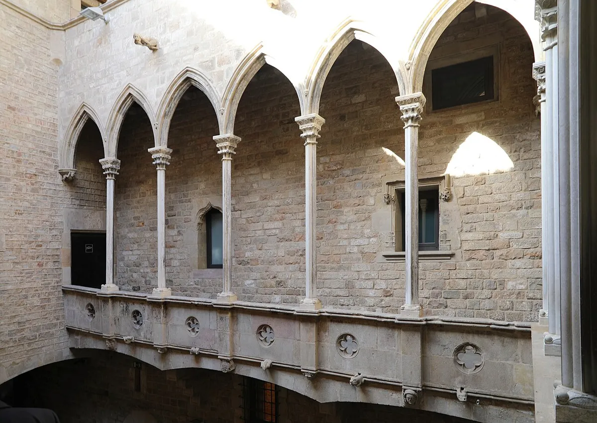
The courtyard gallery of Palau Aguilar, Carrer de Montcada 15, now part of the Museu Picasso. Photo: Francesco Bini, CC BY-SA 4.0, via Wikimedia Commons (resized). Go round the end of the church onto the Passeig del Born. Tournaments, fairs and festivals were held here from the 13th century, and in the 16th century the Inquisition executed its victims here. The iron hall at the far end is the old Mercat del Born. Now turn into Carrer de Montcada. The Montcada family opened it in the mid-12th century, and in the 15th and 16th centuries nobles and rich merchants built the big houses along it that became palaces. It is the most important group of medieval civil buildings in the city. Five of them, numbers 15 to 23, now make up the Museu Picasso.
More history
The historian Albert Garcia Espuche argues that the Passeig del Born was Barcelona's main square in the late 17th and early 18th centuries. In 1714 it was where General Villarroel prepared the last charge of the Catalan cavalry against the besieging army's guns.
Carrer de Montcada was laid out to join two suburbs, la Bòria and Vilanova del Mar, and has had its name since 1283. When Atlantic trade picked up in the late 18th century, Carrer Ample took its place, and after the Eixample was built the palaces were split into flats. Once the Born market opened, many became warehouses. To save the street, a Society of Friends of Carrer de Montcada was founded in 1930, and in 1947 it was declared a monument.
The society's first purchase was Palau Aguilar at number 15, mostly the result of a 15th-century rebuilding. The Museu Picasso opened there on 9 March 1963, the idea of Picasso's friend and secretary Jaume Sabartés. It was the first Picasso museum in the world and the only one created in his lifetime, and it opened as the "Sabartés Collection" because of Picasso's differences with the Franco regime. Across the street, Palau Dalmases at number 20 has a Baroque staircase on twisted Solomonic columns.
Sources: Viquipèdia, Passeig del Born; Viquipèdia, Carrer de Montcada; Viquipèdia, Museu Picasso de Barcelona. Visiting: check hours and tickets on the Museu Picasso site.
-
Mercat de Santa Caterina, the market with the wave roof
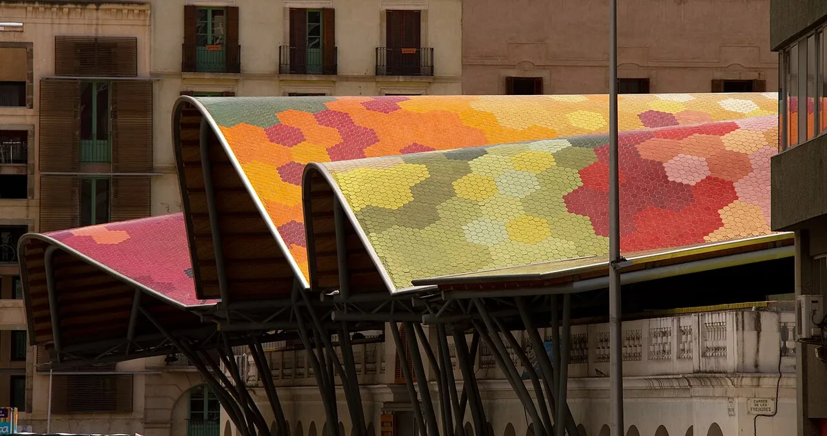
The ceramic roof. Photo: Tony Hisgett, CC BY 2.0, via Wikimedia Commons (resized). Carry on up Carrer de Montcada across Carrer de la Princesa, which cut the street in two in the 19th century, then through Carrer d'en Boquer and Carrer de les Semoleres. The first market here opened on 15 August 1848, on the site of the convent of Santa Caterina, pulled down in 1837. The architects Enric Miralles and Benedetta Tagliabue kept its arcaded fronts and added the wavy roof, covered with 4,200 m² of ceramic tiles in the colours of fruit and vegetables. It reopened on 10 May 2005. At the back, part of the old convent's remains are on show, with panels by the Barcelona History Museum.
More history
The architect Josep Mas i Vila based the covered square on the Saint-Germain market in Paris. One neighbour, the owner of number 3 on the square, refused to give up his house, so the market ended up with three fronts instead of four.
The market was an exception. When church property was seized and sold in 1835, the land freed in the area went to build house-factories for the textile trade, not to public use. In 1914 typhus killed 310 people in Sant Pere, Santa Caterina and La Ribera, 5% of all deaths in Barcelona, and after the 1929 Exhibition drew in workers, the neighbourhood became one of the densest urban areas in Europe.
Sources: Viquipèdia, Mercat de Santa Caterina; Ajuntament de Barcelona, history of Sant Pere, Santa Caterina i la Ribera. Visiting: the market's site.
-
Palau de la Música Catalana, a concert hall for a choir
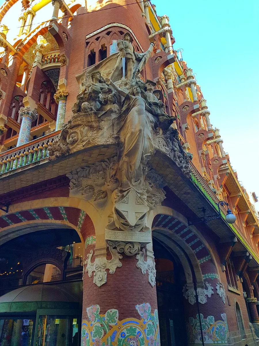
Miquel Blay's sculpture on the corner. Photo: YEEW, CC0, via Wikimedia Commons (resized). Walk up Carrer de Mercaders and Carrer de Verdaguer i Callís to the corner of Carrer de Sant Pere Més Alt. The Orfeó Català, a choir founded in 1891, had this hall built as its home by Lluís Domènech i Montaner; the first stone was laid on 23 April 1905 and it opened on 9 February 1908. On the corner is Miquel Blay's La cançó popular, Folk Song: Saint George below a woman standing for music, among a sailor, farmers, an old man and children. On the second floor look for busts of Palestrina, Bach and Beethoven, with Wagner round the corner. The building is a UNESCO World Heritage Site; to see the hall, take a tour or go to a concert.
More history
The site was the cloister of the convent of Sant Francesc, bought in 1904. The building was paid for with bonds bought by Catalan industrialists and music lovers. The budget doubled, partly because Domènech insisted on finishing a side hidden behind a church as richly as the street fronts. That side, now opened up, has been the main entrance since 1989.
Under Franco the name was put into Spanish and "Catalana" dropped. In 1960, during a visit by Franco, the authorities banned the Cant de la Senyera at the last minute; part of the audience stood and sang it anyway, and there were arrests, among them the young Jordi Pujol, later president of the Generalitat. The Palau became a UNESCO World Heritage Site in 1997, together with the Hospital de Sant Pau.
Source: Viquipèdia, Palau de la Música Catalana. Visiting: tours and concerts on the Palau's official site.
-
Sant Pere de les Puel·les, a convent church from 945
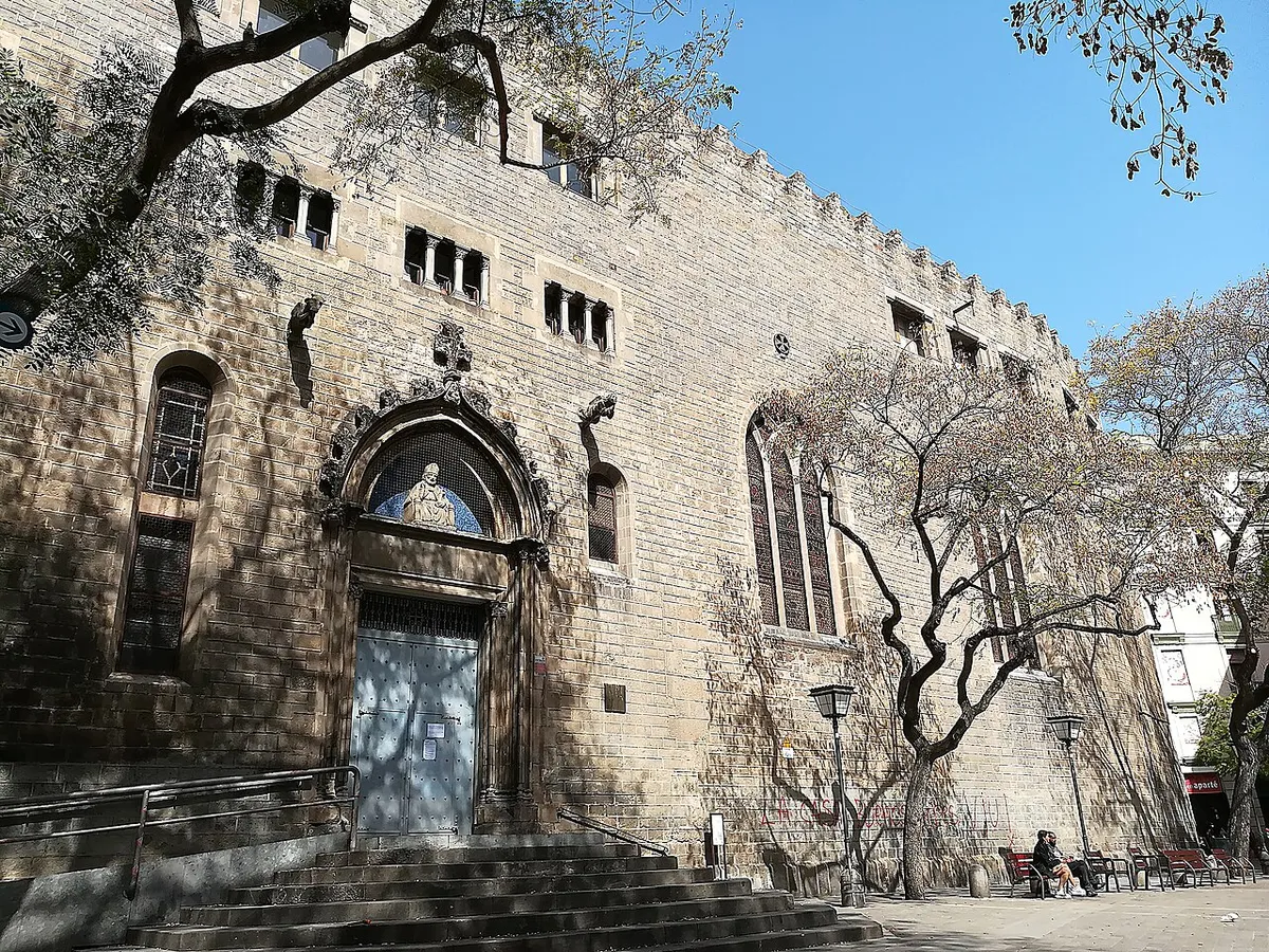
The church from Plaça de Sant Pere. Photo: Enric, CC BY-SA 4.0, via Wikimedia Commons (resized). Follow Carrer de Sant Pere Més Alt to its end at Plaça de Sant Pere. Behind the battlemented front is all that is left of a convent of Benedictine nuns, founded in the first half of the 10th century by Count Sunyer I and Countess Riquilda, whose daughter Adelaida was the first abbess. The church was consecrated on 29 June 945, and the neighbourhood of Sant Pere grew up around it. Look at the 15th-century doorway, with a Gothic statue of Saint Peter above the door. Inside, the oldest part keeps free-standing columns with 10th-century Corinthian capitals.
More history
The convent was destroyed in al-Mansur's raid of 985 and rebuilt. It was hit by bombardments in the sieges of 1697 and 1713–1714, sacked by French troops in 1808, and used as a prison. The nuns were expelled in 1835, the cloister was later pulled down for a new street, and in 1879 the community moved to Sarrià, where it still lives.
The church was burned in the Tragic Week of July 1909, and its bell tower, the Torre dels Ocells, was knocked down straight afterwards. It burned again in 1936. It was reconsecrated in 1945, its thousandth year.
Sources: Viquipèdia, Sant Pere de les Puel·les; Ajuntament de Barcelona, history of Sant Pere, Santa Caterina i la Ribera.
-
Arc de Triomf, the gateway to the 1888 Exhibition
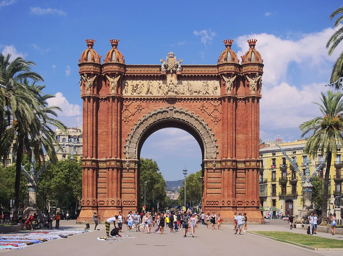
Photo: C messier, CC BY-SA 4.0, via Wikimedia Commons (resized). Take Carrer del Rec Comtal to the wide Passeig de Lluís Companys and walk up to the arch. The architect Josep Vilaseca designed it as the main entrance to the Universal Exhibition of 1888, held in the Parc de la Ciutadella. It is 30 metres tall, of bare brick and glazed tiles on a base of Montjuïc stone. On the side facing the mountain, the stone frieze by Josep Reynés shows Barcelona, crowned, welcoming the nations; on the sea side, Josep Llimona's frieze shows the city handing out the Exhibition's prizes. At the top of each arch, Barcelona's coat of arms sits above the shields of the 49 provinces of Spain in 1888.
More history
The arch replaced a plan for the Torre Comtal, a tower of more than 250 m by Pere Falqués. Its tiles were not finished for the opening: a first batch came out badly and the ceramist Magí Fita fell ill. Most of the Exhibition's buildings were temporary, but the arch became its emblem and survived. It was restored in 1990.
The promenade, 50 m wide, was laid out on the old citadel land as the Saló de Sant Joan, with lamps and iron balustrades by Pere Falqués. The promenade was named after Lluís Companys, the president of the Generalitat executed in 1940, on 20 December 1979.
Sources: Viquipèdia, Arc de Triomf de Barcelona; Viquipèdia, Passeig de Lluís Companys.
-
Parc de la Ciutadella and the Castell dels Tres Dragons
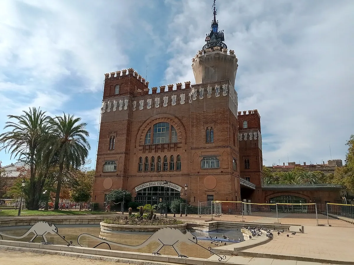
The Castell dels Tres Dragons. Photo: Canaan, CC BY-SA 4.0, via Wikimedia Commons (resized). Walk back down the promenade and keep straight on to the corner of the park. You are now where a fortress stood. After Barcelona fell in 1714, Philip V had a five-pointed citadel built here to control the city. From 1717, 38 streets and 1,016 homes of La Ribera were demolished, and about 4,500 people were thrown out with no compensation. The fortress was handed to the city in 1869; Josep Fontserè laid out a park on it, opened in 1881, which hosted the 1888 Exhibition. The red-brick castle just inside was Lluís Domènech i Montaner's café-restaurant for the Exhibition. Its nickname comes from an 1865 comic play by Pitarra, and its bare brick and iron make it one of the first works of Catalan Modernisme.
More history
The citadel, begun on 1 March 1716 to plans by the military engineer Joris Prosper Van Verboom, became a symbol of repression. The Barceloneta was built from 1753 to ease the housing shortage the demolitions had caused. After the Revolution of 1868, General Prim's government handed the fortress to the city on 12 December 1869, on condition that the land became a public garden. Only three of its buildings survive: the chapel, the governor's palace, now a school, and the arsenal, now the Parliament of Catalonia.
A young Antoni Gaudí worked with Fontserè on the park's Cascada, designing its water system and an artificial grotto beneath it. The café-restaurant was unfinished when the Exhibition opened. Its workshops, known as the "taller dels tres dragons", are seen as the start of Modernisme's decorative arts. Today it houses research laboratories of the Natural Sciences Museum. In 2024 work to restore its front was announced, so you may find it under scaffolding.
Sources: Viquipèdia, Fortalesa de la Ciutadella; Viquipèdia, Parc de la Ciutadella; Viquipèdia, Castell dels Tres Dragons.


_(2).jpg)

.jpg)


Practical details
- Terrain
- Nearly flat. Stops sit between about 10 and 24 m above sea level, highest at Plaça de Sant Pere and lowest at the park. Narrow lanes until stop 5, then wide promenades.
- Step-free
- OpenStreetMap maps a short flight of steps without a ramp on Carrer de l'Argenteria, just after the start, and steps on the side pavement of Passeig de Lluís Companys. It marks Jaume I and Arc de Triomf stations as wheelchair accessible.
- Water
- OpenStreetMap lists free city drinking fountains on the Passeig del Born, in Plaça de Sant Pere, on Carrer de Verdaguer i Callís next to the Palau de la Música, and on Carrer del Davant del Portal Nou, by Passeig de Lluís Companys.
- Toilets
- OpenStreetMap lists toilets at the Mercat de Santa Caterina (stop 3): paid, free with a receipt, wheelchair accessible.
- Sit and eat
- The Mercat de Santa Caterina is a working food market; OpenStreetMap lists Bar Joan and Santa Caterina Cuines there. The Parc de la Ciutadella at the finish has plenty of space to sit.
- When to go
- OpenStreetMap lists the market as closed on Sundays and open from 7:30 the rest of the week, until the afternoon (20:30 on Thursdays and Fridays). On 11 September, Catalonia's national day, the Fossar de les Moreres holds commemorations: expect crowds.
- Shorter walk
- Finish at stop 6, the Arc de Triomf: 2.2 km, about an hour, with the Arc de Triomf metro (L1) and train station right next to it.
- Getting back
- From the finish, Arc de Triomf metro (L1) is about 650 m, 9 minutes on foot. Jaume I (L4) is about 600 m and Barceloneta (L4) about 900 m.
Walking distances and times from the OSRM foot router on OpenStreetMap data. Elevations from Open-Meteo. Metro, fountains, toilets, steps, cafés and market hours from OpenStreetMap. Checked 23 September 2026.
Questions people ask
How long does the El Born walking tour take, and is there a map?
About 75 minutes: 2.6 km, 35 minutes of walking and seven stops, from Jaume I metro to the Parc de la Ciutadella. The map is on this page, and you can print it or save it as a PDF. For about an hour, finish at stop 6, the Arc de Triomf, next to its metro station.
Should I visit the Gothic Quarter or El Born?
They are neighbours, on either side of Via Laietana, and you can walk both in a day. Our Gothic Quarter walk covers Roman Barcino, the cathedral and El Call, and ends at Santa Maria del Mar and the Mercat del Born. This El Born walk starts there and carries on through La Ribera and Sant Pere to the Parc de la Ciutadella.
What is there to do in El Born, Barcelona?
Walk Carrer de Montcada and its medieval palaces, five of which house the Museu Picasso. Stand in the Fossar de les Moreres, the 1714 memorial beside Santa Maria del Mar. Shop at the Mercat de Santa Caterina, see the Palau de la Música Catalana, and end in the Parc de la Ciutadella.
Is El Born the same as La Ribera?
El Born is the lower part of La Ribera, below Carrer de la Princesa, named after the 19th-century Born market. La Ribera, Santa Caterina and Sant Pere together make up one city neighbourhood, Sant Pere, Santa Caterina i la Ribera, in the Ciutat Vella district. This walk passes through all three.
What happened in El Born in 1714?
Barcelona fell on 11 September 1714 after a 14-month siege. The city's defenders were buried in the Fossar de les Moreres, and Philip V then had a fortress, the Ciutadella, built on part of La Ribera: 38 streets and 1,016 homes were demolished and about 4,500 people evicted. The fortress was pulled down after 1869 and became the Parc de la Ciutadella.
Walk it with Strolio
Open Strolio at Jaume I metro and ask for 75 minutes through El Born and La Ribera. Stories play as you reach each place, and you can ask about anything else you pass, by voice or with a photo. This is one example: you can also start from your own street and choose your own time and interests.
More walks in Barcelona
- The Gothic Quarter and El Born: Roman columns, the cathedral and El Call, ending at Santa Maria del Mar and the Mercat del Born, where this walk begins.
- Gaudí and Modernisme on foot: it ends at the Hospital de Sant Pau, by Domènech i Montaner, architect of the Palau de la Música and the Castell dels Tres Dragons.
- Gràcia's village squares: a one-hour walk through the town that joined Barcelona in 1897.
- Montjuïc, from the fountain to the Olympic ring: a longer walk up the hill.
- Hometown walks: shorter walks through Barcelona's neighbourhoods, from Horta to Poblenou.
Sources
- Viquipèdia: Fossar de les Moreres, Passeig del Born, Carrer de Montcada, Museu Picasso de Barcelona, Mercat de Santa Caterina, Palau de la Música Catalana, Sant Pere de les Puel·les, Arc de Triomf de Barcelona, Passeig de Lluís Companys, Fortalesa de la Ciutadella, Parc de la Ciutadella, Castell dels Tres Dragons, Sant Pere, Santa Caterina i la Ribera
- Wikipedia (English): La Ribera
- Ajuntament de Barcelona, Ciutat Vella district: history of Sant Pere, Santa Caterina i la Ribera
- Opening times: Museu Picasso, Mercat de Santa Caterina, Palau de la Música Catalana
- Map data and places: © OpenStreetMap contributors, ODbL
- Elevations: Open-Meteo
- Photos: Wikimedia Commons contributors böhringer friedrich, Francesco Bini, Tony Hisgett, YEEW, Enric, C messier and Canaan, credited under each photo