
Red Light District self-guided walking tour · 75 minutes · map
Amsterdam's old centre and Red Light District on foot: from Centraal Station to the Begijnhof
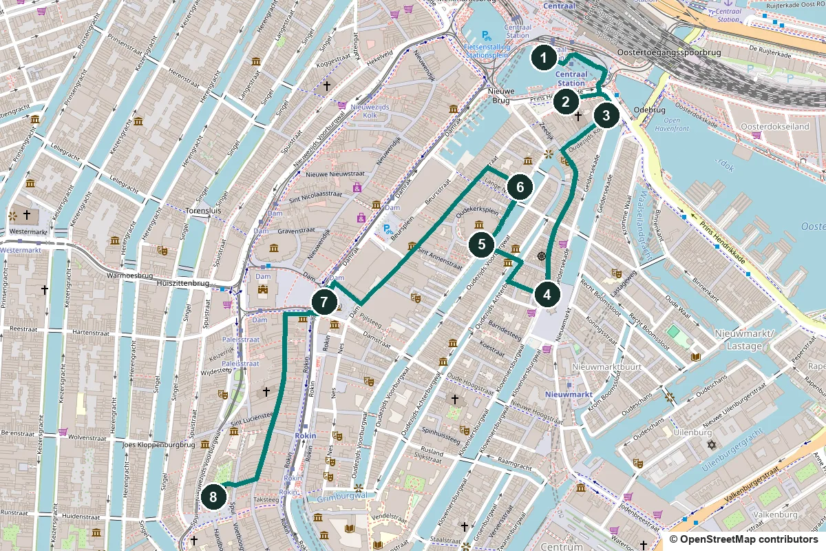
Amsterdam started here, around a dam on the Amstel. This 75-minute walk goes from Centraal Station along the old harbour front, down the Zeedijk and through De Wallen, the Red Light District, to the Dam and the quiet Begijnhof. Three of its stops are churches dedicated to St Nicholas, the city's patron saint.
The dam that gave the city its name was most likely built between 1265 and 1275. East of the river grew the Oude Zijde, the old side. Its canals, the Oudezijds Voorburgwal and the Oudezijds Achterburgwal, were moats with earth walls behind them, which is where the name De Wallen comes from. Prostitution has been part of this quarter since the 15th century or earlier. Between 1481 and 1494 the town was ringed with a brick wall. Its only surviving defence tower and one of its gates are both on this walk.
A note on accuracy: where a building has been rebuilt, or a date is disputed, we say so, and every fact links to its source.
- Start
- Amsterdam Centraal, on the square in front of the main entrance (trains, metro, trams)
- Finish
- The Begijnhof, 190 m from Rokin metro and 140 m from the Koningsplein tram stop
- Distance
- 2.5 km, one way
- Time
- About 75 minutes: 33 min walking and 8 stops, plus any visit to the Oude Kerk, Our Lord in the Attic or the Royal Palace
Red Light District rules, toilets, opening days and a shorter version ↓
What to see: the stops
-
Amsterdam Centraal, a station on three artificial islands
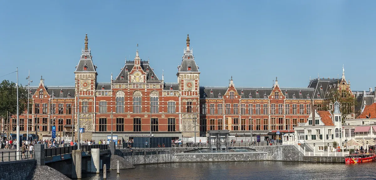
The station front, with the clock tower on the right. Photo: Slaunger, CC BY-SA 4.0, via Wikimedia Commons (resized). Stand on the square in front of the main entrance and look back at the building. Pierre Cuypers was the lead architect, with Dolf van Gendt designing the station building, and it went up between 1881 and 1889. It stands on three islands made in the IJ with dune sand dug out for the North Sea Canal, and rests on 8,687 wooden piles. The city council had not wanted a railway cutting the city off from the IJ, but agreed to this site in 1869. Cuypers gave the front two towers to mark it as a new city gate: the eastern one holds a clock, the western one a wind vane. Cuypers also designed the Rijksmuseum, finished in 1885, and the two look alike. The station opened on 15 October 1889 to huge crowds.
More history
The roof over the tracks, 50 curved trusses spanning almost 45 metres, was designed by the engineer L.J. Eijmer. On the east side is a royal waiting room.
Sources: Wikipedia (nl), Station Amsterdam Centraal; Wikipedia, Amsterdam Centraal station.
-
The Basilica of St Nicholas, the third church of the city's saint
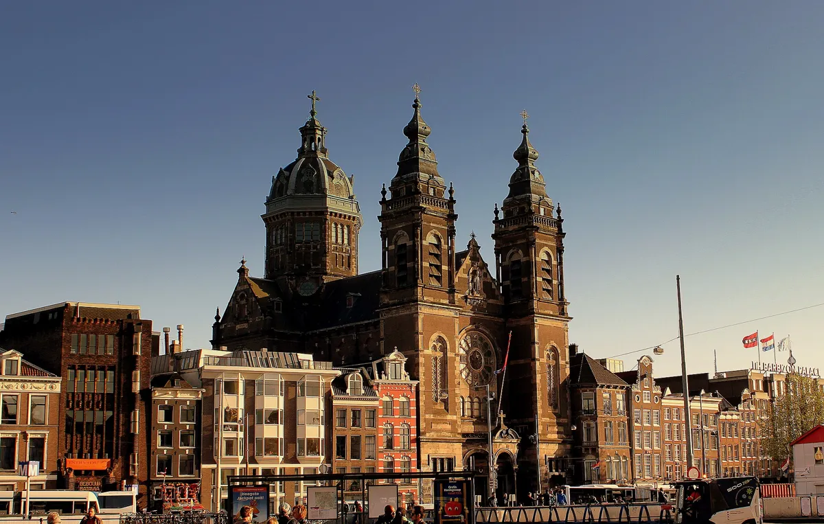
The basilica above the Prins Hendrikkade. Photo: calflier001, CC BY-SA 2.0, via Wikimedia Commons (resized). Cross the square and the water in front of the station to the Prins Hendrikkade. The basilica is across the road on your left. The architect Adrianus Bleijs designed it, and it was built from 1884 to 1887 and consecrated on 7 February 1887. He chose neo-Renaissance and neo-Baroque, when Catholic churches were usually neo-Gothic. This is the third Amsterdam church dedicated to St Nicholas of Myra. The first is the Oude Kerk, which became Protestant in 1578. The second was a hidden Catholic church on the Oudezijds Voorburgwal, now known as Our Lord in the Attic. You will see both later on this walk.
More history
The church became a basilica in 2012. In 2025 Pope Francis made it a co-cathedral of the diocese of Haarlem-Amsterdam, a gift for the city's 750th anniversary.
Sources: Wikipedia (nl), Basiliek van de Heilige Nicolaas; Wikipedia, Basilica of Saint Nicholas.
-
The Schreierstoren, a tower from the medieval wall
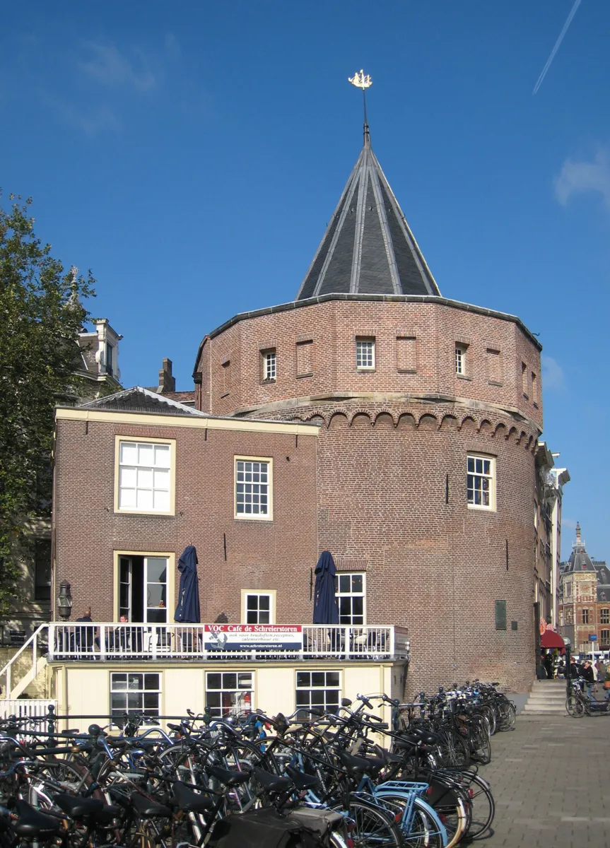
The tower on the corner of the Geldersekade. Photo: S Sepp, CC BY-SA 3.0, via Wikimedia Commons (resized). Carry on east along the Prins Hendrikkade to the round brick tower on the corner of the Geldersekade. It was built around 1487 as part of the city wall, at the point where the wall turned sharply from the harbour front to run south-east along the moat, today's Geldersekade, to the gate on the Nieuwmarkt. That sharp corner gave it its old name, from schray, "sharp". The popular story is that wives wept (schreien) here as their sailors left, but it is probably a myth that grew from the similar words. A stone from 1569 helped it along: it shows a weeping woman pointing at her sailor's departing ship. A plaque from 1927 records that Henry Hudson sailed from here on 4 April 1609 for the Dutch East India Company.
More history
Large sandstone blocks in the Geldersekade quay wall are left from the city wall. The tower was a harbour office until 1960 and now houses a café, with a shop for charts and nautical books upstairs.
Sources: Wikipedia (nl), Schreierstoren; Wikipedia, Schreierstoren.
-
The Zeedijk and the Waag on the Nieuwmarkt
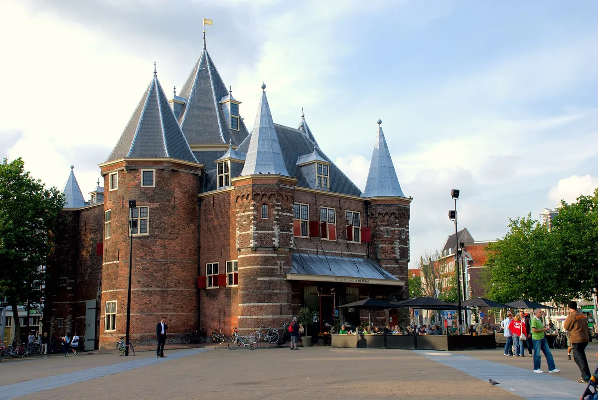
The Waag on the Nieuwmarkt. Photo: Kmhofmann at English Wikipedia, CC BY-SA 3.0, via Wikimedia Commons (resized). Walk back west along the Oudezijds Kolk and turn left into the Zeedijk. About 70 m to your right, at Zeedijk 1, is In 't Aepjen, built between 1546 and 1550 and one of the city's two surviving houses with a wooden front. The Zeedijk was built as a dike against the IJ, and its bend still follows it. Today it runs through Chinatown. Follow it to the Nieuwmarkt. The gatehouse in the middle is the Waag, once St Anthony's Gate. Its corner tower carries Amsterdam's oldest gable stone, which says the first stone was laid on 28 April 1488, though older documents already mention the gate. In 1614 the moat around the gate was covered over to make this square. From 1617 it was a weigh house, with guilds upstairs. Over the surgeons' door is written "Theatrum Anatomicum": their guild ordered Rembrandt's The Anatomy Lesson of Dr Nicolaes Tulp (1632) for its rooms here.
More history
The square lay in the old Jewish quarter. In the Second World War the German occupiers used it as an assembly point for deporting Jewish Amsterdammers. In 1975 the demolition of houses for the metro led to the Nieuwmarkt riots.
Sources: Wikipedia (nl), Waag; Wikipedia, Waag; Wikipedia (nl), Nieuwmarkt; Wikipedia (nl), Zeedijk; Wikipedia (nl), In 't Aepjen.
-
Through De Wallen to the Oude Kerk, Amsterdam's oldest building
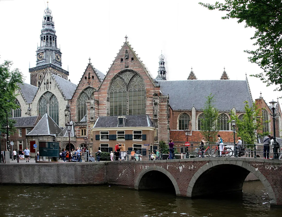
The Oude Kerk across the Oudezijds Voorburgwal. Photo: Gerd Eichmann, CC BY-SA 4.0, via Wikimedia Commons (resized). Leave the Nieuwmarkt on its west side along the Monnikenstraat. At the canal, the Oudezijds Achterburgwal, turn right, then left into the narrow Oudekennissteeg, which leads through to the Oudekerksplein. You are now in De Wallen, an area of about 250 by 250 metres with just over 300 windows where sex workers rent rooms. People live and work here: don't photograph the sex workers (see the rules below). On the square, Els Rijerse's bronze Belle (2007) carries the words "Respect sex workers all over the world". The church in the middle is the Oude Kerk, Amsterdam's oldest building. The church dates its first wooden chapel to about 1250 (some sources say about 1213), and on 17 September 1306 the Bishop of Utrecht consecrated the church to St Nicholas, patron saint of sailors. Once the Nieuwe Kerk on the Dam was consecrated in 1409, this became the "old church". It turned Protestant in 1578. Around 60,000 people were buried under its floor until 1865, among them Rembrandt's wife Saskia Uylenburgh.
More history
The text on the choir screen refers to 1578: "the misuse, gradually brought into God's church, was here again undone in the year seventy-eight". Today the church shows contemporary art, and Protestant services still take place on Sundays.
Sources: Oude Kerk, About; Wikipedia (nl), Oude Kerk; Wikipedia, Oude Kerk; Wikipedia (nl), De Wallen; Wikipedia (nl), Belle. Visiting: hours and tickets on the Oude Kerk's site.
-
Our Lord in the Attic, a hidden church in a canal house
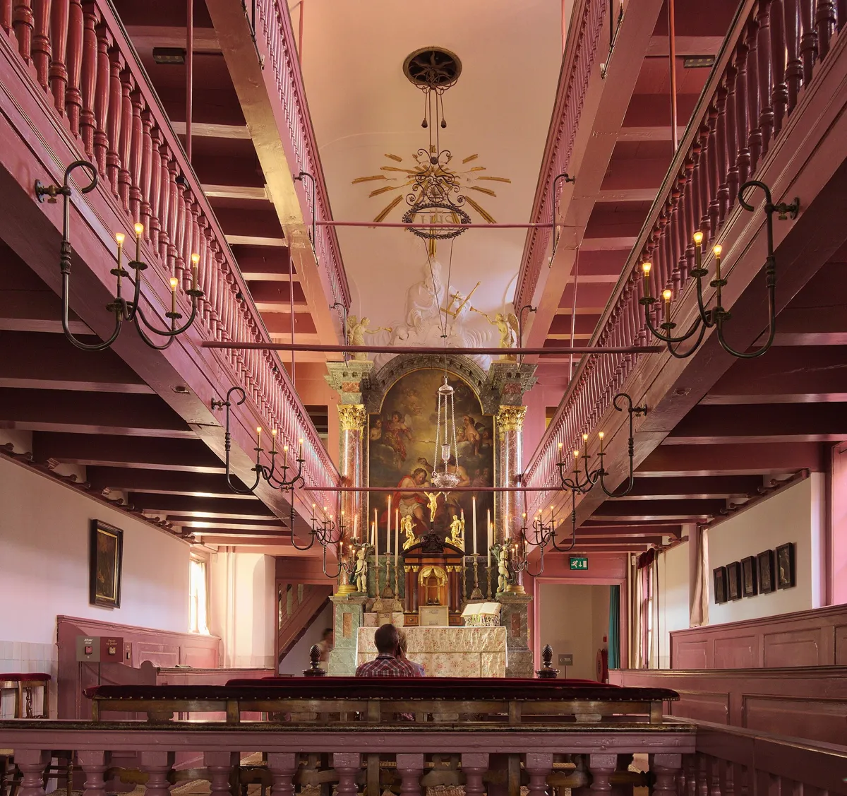
The church in the attic, with its galleries. Photo: C messier, CC BY-SA 4.0, via Wikimedia Commons (resized). Walk north along the Oudezijds Voorburgwal, with the canal on your right, to number 40, on the corner of the alley Heintje Hoekssteeg. From the street it looks like an ordinary canal house from about 1630. After 1578 Catholic Mass was banned from public churches, but the city tolerated services held in private houses. On 10 May 1661 Jan Hartman, a Catholic merchant from Coesfeld in Germany, bought this house and the two houses in the alley behind it. He joined their three attics into one church with room for 150 people, who came in through the alley at the side. Above the altar hangs Jacob de Wit's Baptism of Christ of 1716. The church served for more than two centuries, until the Basilica of St Nicholas (stop 2) replaced it. It opened as a museum on 28 April 1888, the second-oldest in Amsterdam after the Rijksmuseum.
More history
Hartman died in April 1668 and was buried in the Oude Kerk, and his debts later forced the family to sell. The base of one altar column folds out into a pulpit, to save space.
Sources: Museum Ons' Lieve Heer op Solder, The monument; Wikipedia (nl), Museum Ons' Lieve Heer op Solder; Wikipedia, Ons' Lieve Heer op Solder. Visiting: opening hours and tickets.
-
The Dam: Royal Palace, Nieuwe Kerk and National Monument
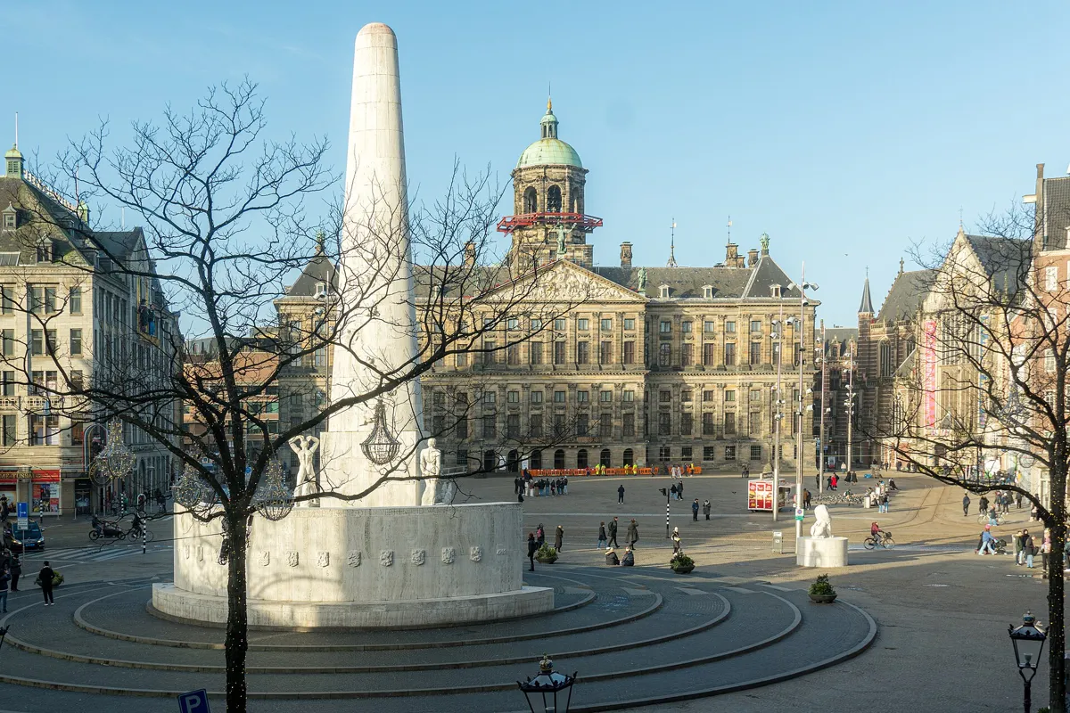
The National Monument and the Royal Palace. Photo: Fernando, CC BY-SA 4.0, via Wikimedia Commons (resized). Turn left into the Heintje Hoekssteeg, then left again along the Warmoesstraat, one of the city's 13th-century streets, and follow it to the Dam. Behind the plain 19th-century front of Warmoesstraat 90, on your way, a timber frame from about 1485 was found in 2012. Across the square stands the Royal Palace, built from 1648 as the city hall to a design by Jacob van Campen and inaugurated on 29 July 1655. It was built on 13,659 wooden piles. In 1808 it became the palace of King Louis Napoleon, who had the old weigh house on the Dam pulled down because it spoiled his view. To its right is the Nieuwe Kerk, consecrated in 1409, where Dutch monarchs are sworn in, most recently Willem-Alexander in 2013. Facing the palace is the National Monument, a 22-metre pillar designed by J.J.P. Oud with sculpture by John Rädecker, unveiled by Queen Juliana on 4 May 1956. The national remembrance of the war dead is held here every 4 May.
More history
The Nieuwe Kerk burned out in 1645, in a fire started by plumbers working under the roof, and was rebuilt in Gothic style. Admiral Michiel de Ruyter is buried in it.
Sources: Wikipedia (nl), Dam; Wikipedia, Dam Square; Wikipedia (nl), Paleis op de Dam; Wikipedia, Royal Palace of Amsterdam; Wikipedia (nl), Nieuwe Kerk; Wikipedia, Nieuwe Kerk; Wikipedia (nl), Nationaal Monument op de Dam; Wikipedia, National Monument; Wikipedia (nl), In 't Aepjen (Warmoesstraat 90). Visiting: the Royal Palace and De Nieuwe Kerk.
-
The Begijnhof and the Houten Huys
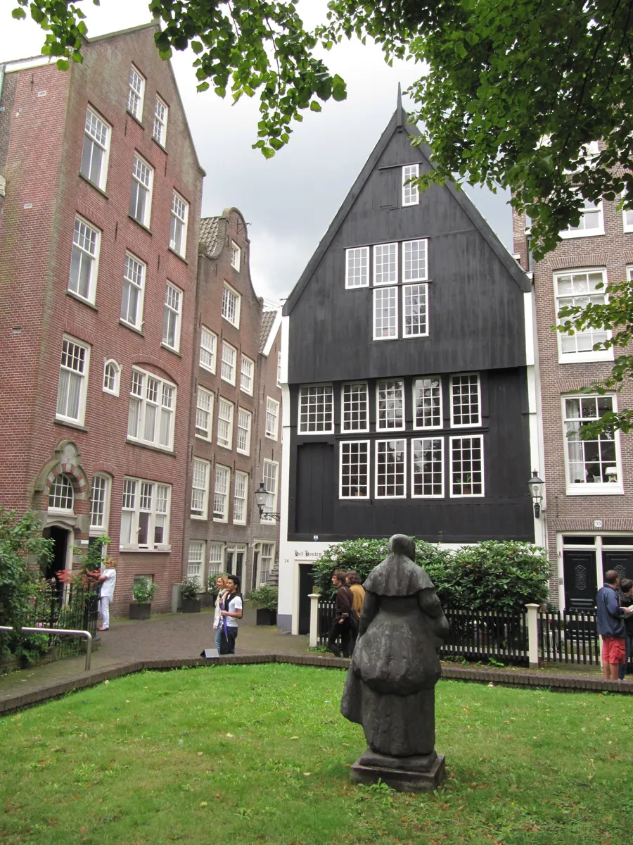
Het Houten Huys, Begijnhof 34. Photo: M.M.Minderhoud, CC BY-SA 3.0, via Wikimedia Commons (resized). Cross the square to the Kalverstraat, the shopping street leaving the Dam to the south, and after about 350 m turn right into the narrow Begijnensteeg. Its gateway opens into the Begijnhof. Until the Spui entrance was made in the 19th century, this was the only way in. It is the only courtyard founded in medieval Amsterdam. Beguines were women who vowed to stay chaste but, unlike nuns, could leave to marry. After 1578 the Begijnhof was the only Catholic institution allowed to carry on, because the houses were the beguines' own property. Their chapel was handed to English Presbyterians and is still the English Reformed Church; in 1671 Philips Vingboons turned two houses opposite into a hidden Catholic church. At number 34 stands Het Houten Huys, with a wooden front and an overhanging top floor. It was long dated to about 1420; according to the Dutch Wikipedia, research in 2012 put it at 1528 or soon after, but sources still disagree. With In 't Aepjen on the Zeedijk, it is one of the last two wooden fronts in the city. Today 105 women live here, so keep your voice down.
More history
The beguine Cornelia Arens, who died in 1654, asked to be buried in the gutter rather than in the "desecrated" chapel. Legend says her coffin kept turning up in the gutter until her wish was granted. The last beguine died in 1971.
Sources: Wikipedia (nl), Begijnhof; Wikipedia, Begijnhof; Wikipedia (nl), Het Houten Huys.


Practical details
- Red Light District rules
- The City of Amsterdam's ten rules for visitors (as published in May 2026) include: no photos of sex workers; no smoking cannabis in public in the city centre (use a coffeeshop); no drinking alcohol in public in the centre; keep the noise down, especially at night; never urinate in the street; and never buy drugs from street dealers. Fines for nuisance run from €100 to €650. Watch for pickpockets in crowds. The area is busiest in the evening. Rules change, so check the current ones on amsterdam.nl.
- Terrain
- Flat, on paved streets, narrow alleys and a few low canal bridges. The Begijnhof lies almost a metre below the streets around it.
- Step-free
- The walking route uses no steps mapped in OpenStreetMap. Most of the Oude Kerk's main hall is wheelchair accessible, but its side rooms are not. Our Lord in the Attic means many narrow stairs, though its café, shop and exhibition space have a lift. OpenStreetMap marks Centraal Station and the Rokin metro entrance near the finish as wheelchair accessible.
- Water
- OpenStreetMap lists Waternet drinking taps on the Nieuwmarkt by the Waag, near the Oude Kerk and by the Begijnhof.
- Toilets
- OpenStreetMap shows free public toilets, open around the clock but not wheelchair accessible, by the Oude Kerk and on the Nieuwmarkt, and toilets on the fifth floor of the Bijenkorf on the Dam. The Oude Kerk and Our Lord in the Attic have toilets for visitors.
- Sit and eat
- The Nieuwmarkt (stop 4) is lined with cafés, and the Waag has a café-restaurant. The Oude Kerk's café, the Koffieschenkerij, is in the former sacristy on the Oudekerksplein, with a courtyard garden; it opens daily from 09:00 to 18:00.
- When to go
- The Oude Kerk opens Monday to Saturday 10:00–18:00 and Sunday 13:00–17:30; it closes on 27 April, 25 December and while exhibitions change (in 2026, 9–12 November). Our Lord in the Attic opens daily 10:00–18:00 (11:00 on the first Sunday of the month, September to June) and closes on 27 April and 25 December; booking ahead is advised. The Royal Palace opens on more than 230 days in 2026, from 10:00, but not every day, so check its calendar. De Nieuwe Kerk opens daily 10:00–17:00 for exhibitions, with some closed days. All four charge for entry; check before you go.
- Shorter walk
- Finish at stop 7, the Dam: 1.9 km, about an hour. Centraal Station is about 900 m back down the Damrak.
- Getting back
- From the Begijnhof, Rokin metro is about 190 m and the Koningsplein tram stop about 140 m away. Walking back to Centraal Station is about 1.5 km, 20 minutes.
Walking distances and times from the OSRM foot router on OpenStreetMap data. Stations, drinking taps and toilets from OpenStreetMap; visitor rules from the City of Amsterdam; opening hours from the Oude Kerk, Our Lord in the Attic, the Royal Palace and De Nieuwe Kerk. Checked 4 October 2026.
Questions people ask
How long is the walk, and how far is the Dam from Centraal Station?
This walk is 2.5 km, 33 minutes of walking, and about 75 minutes with its eight stops, from Centraal Station through the Red Light District to the Dam and the Begijnhof. If you only want the Dam, it is about 900 m straight down the Damrak, around 12 minutes on foot. The map is on this page, and you can print it or save it as a PDF.
Can you walk through the Red Light District, and is it safe?
Yes. Its streets and canals are public, and this route walks a short stretch of the Oudezijds Achterburgwal and passes the Oude Kerk. The city asks visitors to keep the noise down, warns that pickpockets work in crowded places and says never to buy drugs from street dealers, because what they sell is often fake and dangerous. Fines for nuisance run from 100 to 650 euros. The area is busiest in the evening. From 1 April 2020 the city banned guided tours past the sex workers' windows.
Can you take photos in the Red Light District?
Not of the sex workers. The City of Amsterdam's rules for visitors say taking pictures of them is not allowed. Inside the Oude Kerk, photos are allowed without flash.
What is the oldest building in Amsterdam?
The Oude Kerk, in the middle of the Red Light District. The church dates its first wooden chapel to about 1250 (some sources say about 1213), and it was consecrated on 17 September 1306. The Waag on the Nieuwmarkt, a 15th-century city gate, is the oldest surviving building that is not a church. Of the city's two houses with wooden fronts, In 't Aepjen on the Zeedijk was built between 1546 and 1550, and the Houten Huys in the Begijnhof was long dated to about 1420, though research in 2012 reported by the Dutch Wikipedia puts it at 1528 or soon after.
Can you visit the Begijnhof?
Yes. This walk goes in through the gate at the end of the Begijnensteeg, an alley off the Kalverstraat; a second entrance, on the Spui, dates from the 19th century. It is not a museum but a courtyard of homes where 105 women live, so keep your voice down. Its former hidden Catholic church stands opposite the entrance of the English Reformed Church.
Walk it with Strolio
Open Strolio at Centraal Station and ask for 75 minutes through Amsterdam's old centre. Strolio builds walks in any city with mapped streets, so its route may pick different stops from this page. Stories play as you reach each place, and you can ask about anything else you pass, by voice or with a photo. You can also start from your hotel and choose your own time and interests.
More walks in Amsterdam
- The Jordaan: ~80 min, 8 stops. The Nine Streets, Rembrandt's Westerkerk, the Anne Frank House, a 1650 widows' courtyard and the Brouwersgracht.
- The Jewish Quarter: ~75 min, 8 stops. Rembrandt's house, two 17th-century synagogues, the February Strike statue and the Holocaust memorials of the Weesperstraat and Plantage.
- The Canal Ring to Museumplein: ~90 min, 8 stops. From the Munttoren and the Golden Bend to the Magere Brug, then a walk through the Rijksmuseum itself.
- All Amsterdam walks, with maps side by side.
- Walks in other cities.
Sources
- City of Amsterdam, How to Amsterdam: the ten rules for visitors, including no photos of sex workers (read from the Wayback Machine copy of 8 May 2026, as the live page blocks automated access). We used their facts and wrote our own text.
- City of Amsterdam, Regels voor rondleidingen in stadsdeel Centrum (Wayback Machine copy, April 2022): no guided tours past sex workers' windows since 1 April 2020.
- Wikipedia (Dutch): Station Amsterdam Centraal, Basiliek van de Heilige Nicolaas, Schreierstoren, Zeedijk, In 't Aepjen, Waag, Nieuwmarkt, De Wallen, Belle, Oude Kerk, Museum Ons' Lieve Heer op Solder, Dam, Paleis op de Dam, Nieuwe Kerk, Nationaal Monument op de Dam, Begijnhof, Het Houten Huys
- Wikipedia (English): Amsterdam Centraal station, Basilica of Saint Nicholas, Schreierstoren, Waag, De Wallen, Oude Kerk, Ons' Lieve Heer op Solder, Dam Square, Royal Palace of Amsterdam, Nieuwe Kerk, National Monument, Begijnhof
- History, opening times and visits: Oude Kerk, About, Oude Kerk, opening hours, Oude Kerk, FAQ, Oude Kerk, accessibility, Our Lord in the Attic, The monument, opening hours, accessibility, Royal Palace Amsterdam, De Nieuwe Kerk
- Map data and places: © OpenStreetMap contributors, ODbL; walking route from the OSRM foot router run by FOSSGIS
- Photos: Wikimedia Commons contributors Slaunger, calflier001, S Sepp, Kmhofmann, Gerd Eichmann, C messier, Fernando and M.M.Minderhoud, credited under each photo