
Jordaan self-guided walking tour · 80 minutes · map
The Jordaan on foot: Rembrandt's church, Anne Frank's house and a courtyard for widows
The Jordaan was built in the 17th century as Amsterdam's district for workers and craftsmen, just west of the grand canal ring. This walk starts in the Nine Streets, passes the Westerkerk and the Anne Frank House on the Jordaan's edge, then goes in for quiet canals, a 1650 courtyard for widows and a market square.
Building began in 1612, when the city expanded west. The new district, first called Het Nieuwe Werck (the New Work), kept the lines of the old polder ditches and paths, so its streets run at an angle to the canal ring next door. Many are named after flowers and trees. In the 19th century it was poor and overcrowded, and six of its eleven canals were filled in. Plans in the 1950s to pull much of it down found no support, and in 1972 it became a protected townscape. Today it is one of the most expensive places to live in the Netherlands.
A note on accuracy: the first four stops are on the canal ring, just outside the Jordaan proper. Some fronts you will see are 1940s reconstructions, and Rembrandt's grave can no longer be found. Where that matters we say so, and every fact links to its source.
- Start
- Spui, by the Singel, 90 m from the Koningsplein tram stop and about 200 m from Rokin metro
- Finish
- Lekkeresluis bridge, where the Prinsengracht meets the Brouwersgracht, about 950 m from Amsterdam Centraal
- Distance
- 3.1 km, one way
- Time
- About 80 minutes: 41 min walking and 8 stops, plus any visit inside
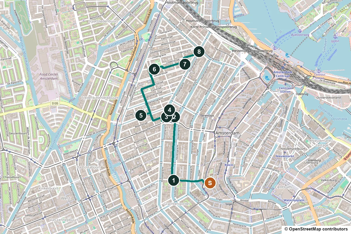
Terrain, water, opening days and a shorter version ↓
What to see: the stops
-
The Nine Streets, named after the leather trade
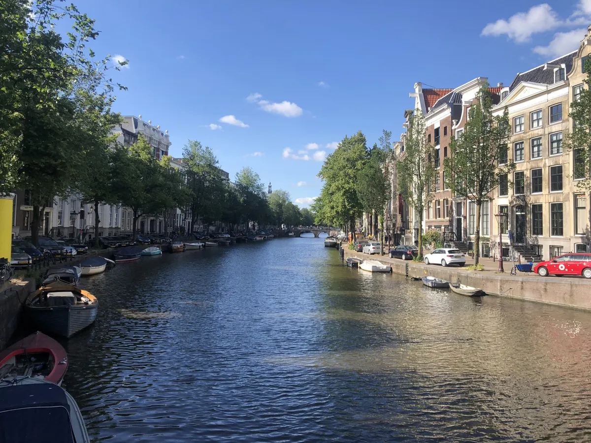
The Keizersgracht in the Nine Streets. Photo: JayAmber, CC BY-SA 4.0, via Wikimedia Commons (resized). From Spui, take the narrow Heisteeg west over the Singel, follow the Wijde Heisteeg across the Herengracht, and carry on along Huidenstraat to the Keizersgracht bridge. You are in the Nine Streets: three rows of three short streets crossing the canal ring between the Singel and the Prinsengracht. Most names come from the trades that worked animal skins here. Huidenstraat means Skins Street, and Runstraat is named after run, ground oak bark used to tan leather; Reestraat, Berenstraat and Wolvenstraat remember roe deer, bears and wolves. The land was laid out from about 1612, but most buildings are 18th-century, and more than 140 are listed monuments. The name is recent: shopkeepers founded the De 9 Straatjes association on 12 November 1996 to promote the area.
More history
Nobody much liked the name at first, but it stuck. Success brought higher rents and worries that chains were pushing out small independent shops. The canal ring around you is a UNESCO World Heritage Site.
Sources: Wikipedia (nl), De 9 Straatjes; Wikipedia, Negen Straatjes.
-
The Homomonument, three pink triangles
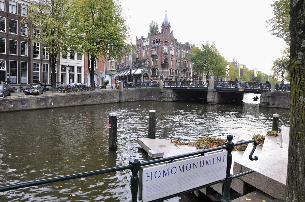
The triangle on the water, which stands for the present. Photo: Hnapel, CC0, via Wikimedia Commons (resized). Walk north along the west bank of the Keizersgracht, across the busy Raadhuisstraat, to the Westermarkt. Between the church and the canal lie three pink granite triangles, joined into one large triangle with 36-metre sides. This is the Homomonument, unveiled on 5 September 1987: the world's first memorial to people persecuted for their sexual orientation. The pink triangle recalls the symbol that homosexual victims of the Nazi regime had to wear on their clothes. The artist Karin Daan gave each triangle a time. The steps down to the water are the present and point to Dam Square. The raised triangle is the future and points to the former office of the COC, the Dutch gay rights group. The triangle set flat in the paving is the past and points to the Anne Frank House. Its inscription, by the poet Jacob Israël de Haan, reads Naar vriendschap zulk een mateloos verlangen: "for friendship such an immoderate desire".
More history
The idea was already being discussed in the COC in 1961. On 4 May 1970 two young activists were arrested for trying to lay a wreath at the national remembrance on Dam Square. In 1980 a design competition was held, won by the artist Karin Daan, and donors and governments raised the 400,000 guilders needed to build it. A commemoration has been held here every 4 May, Remembrance Day, since 1988.
Sources: Homomonument, the design; Homomonument, our history; Wikipedia, Homomonument.
-
The Westerkerk, where Rembrandt was buried
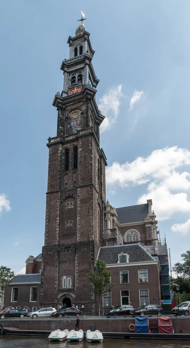
The Westertoren from the Prinsengracht. Photo: Dietmar Rabich, CC BY-SA 4.0, via Wikimedia Commons (resized). Walk round the church to its tower on the Prinsengracht. Hendrick de Keyser designed the Westerkerk; building began in 1620, and after his death in 1621 his son Pieter finished it. It opened on 8 June 1631 and is still the largest church in the Netherlands built for Protestants. The Westertoren is Amsterdam's tallest church tower, about 85 metres, or 87 with the weathervane. On top is the imperial crown of Maximilian I, repainted in its original blue in 2006. Rembrandt, who spent his last years nearby on the Rozengracht, was buried here on 8 October 1669. Nobody knows exactly where; a plaque on the north wall remembers him. The church is open, free, on weekdays from 11:00 to 15:00. The tower climb is closed for restoration.
More history
Rembrandt was buried as a poor man, and after twenty years his remains were cleared, as was usual for the poor. His son Titus and his partner Hendrickje Stoffels lie here too. Anne Frank could see the tower's clock from the attic of her hiding place and wrote of its bells as a comfort. At the request of Jordaan residents the carillon chimes day and night, with concerts usually on Tuesdays from 12:00 to 13:00. On 10 March 1966 Princess Beatrix married Claus von Amsberg here.
Sources: Westerkerk, visit; Westerkerk, tourist information; Wikipedia, Westerkerk; Wikipedia (nl), Westerkerk.
-
The Anne Frank House at Prinsengracht 263
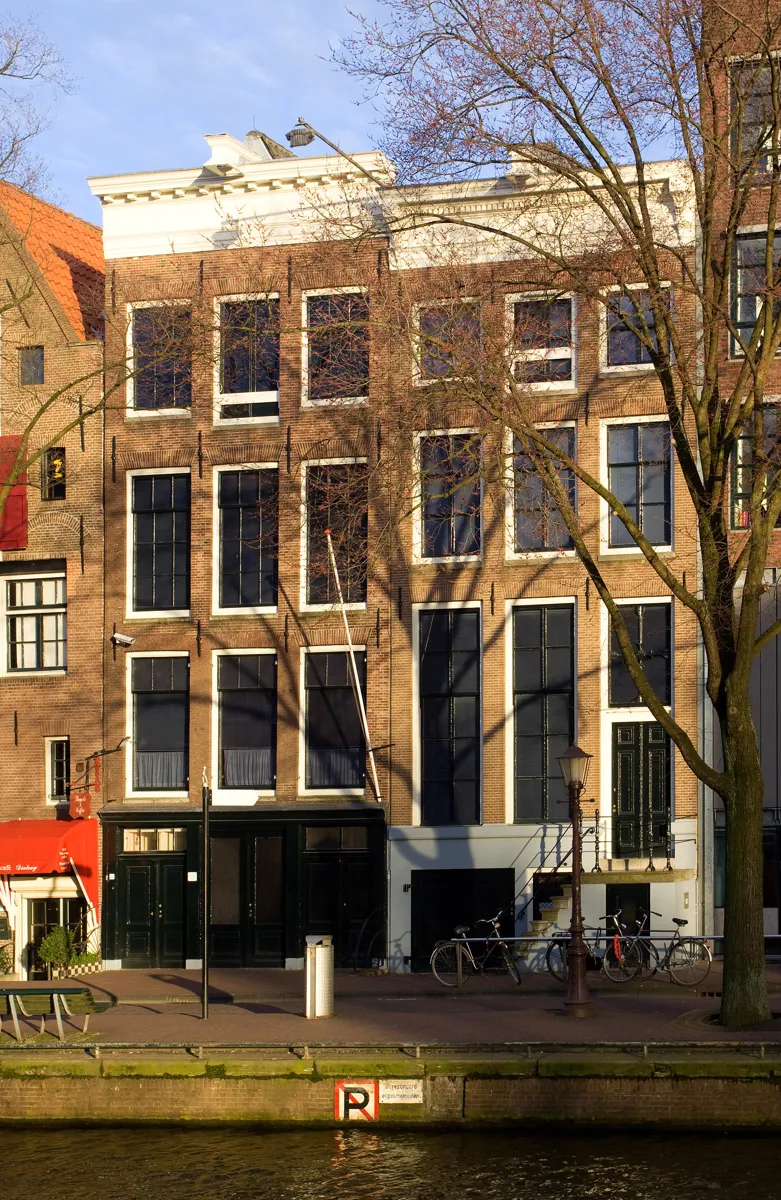
The museum's canal front on the Prinsengracht. Photo: Massimo Catarinella, CC BY-SA 3.0, via Wikimedia Commons (resized). Walk 80 metres north along the Prinsengracht to number 263, built in 1635. On 1 December 1940 Otto Frank moved his firms here. On 5 July 1942 his elder daughter Margot received a call-up to report for a so-called "labour camp" in Nazi Germany, and the next day the family went into hiding in the back house, the Achterhuis. Four more Jews joined them, and a revolving bookcase was fitted to hide the way in. The eight stayed hidden for two years and one month, until they were found and arrested on 4 August 1944. Only Otto survived the camps; Anne died in Bergen-Belsen at the end of February 1945. Two helpers, Miep Gies and Bep Voskuijl, saved her diary, published in Dutch in 1947 as Het Achterhuis. The museum entrance is round the corner at Westermarkt 20. Tickets are sold only online, for a set time slot, never at the door.
More history
In 1955 the building's owner planned to pull it down, but there was a public outcry. The Anne Frank Foundation was set up on 3 May 1957, and the museum opened on 3 May 1960. In 2019 it had a record 1.3 million visitors.
Sources: Anne Frank House, tickets and opening hours; Anne Frank House, who was Anne Frank?; Wikipedia (nl), Anne Frank Huis; Wikipedia, Anne Frank House.
-
The Bloemgracht and the Drie Hendricken of 1642
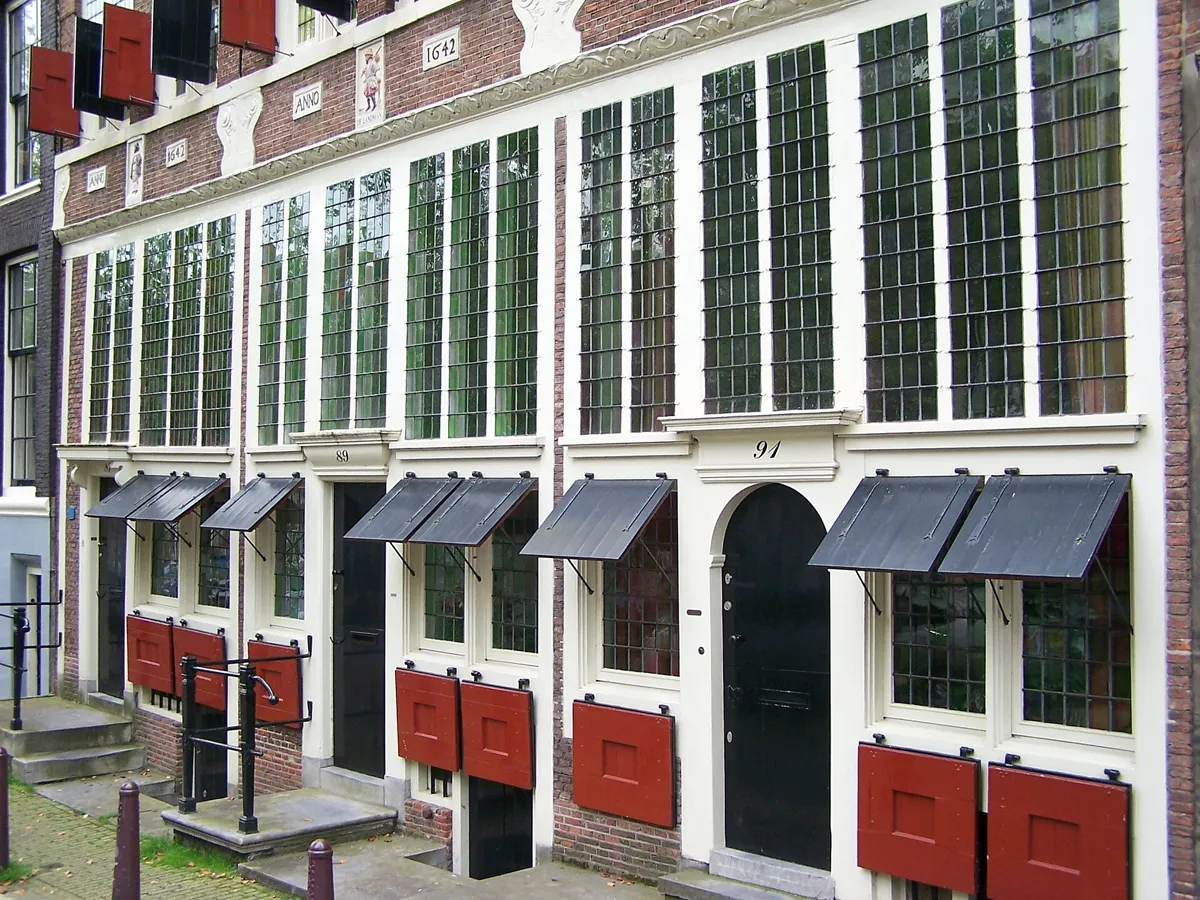
Bloemgracht 87–91, with the 1642 date stones and a gable stone. Photo: Spider, CC BY-SA 3.0, via Wikimedia Commons (resized). Walk back to the Westermarkt and cross the Prinsengracht. Turn right, then left into Bloemstraat, right up Eerste Bloemdwarsstraat over the Bloemgracht, and left along its north bank. You are now in the Jordaan. This canal, named after a bastion called De Bloem, was dug in the first half of the 17th century. In 1623 the city sent cloth dyers here, and from 1635 the Blaeu family made maps on this canal, including their great Atlas Maior. Across the water, numbers 87, 89 and 91 are the Drie Hendricken: three stepped-gable houses with date stones reading ANNO 1642. Their gable stones show a townsman, a farmer and a sailor: three ways of life in the 17th century, not the trades of the first owners. Note the ground floors. Their wooden fronts with leaded windows and shutters were rebuilt in the 1940s from traces found in the walls.
More history
The heritage society Vereniging Hendrick de Keyser bought the houses in 1927–1929, and architect Jan de Meijer restored them between 1943 and 1947. Rebuilding them to their supposed first state was debated at the time. The writer Mies Bouhuys called the Bloemgracht the Herengracht of the Jordaan: the well-off lived on the canal, ordinary people in the side streets.
Sources: Rijksmonumentenregister, Bloemgracht 87; Hendrick de Keyser Monumenten, De Steeman; Wikipedia (nl), De Drie Hendricken; Wikipedia, De Drie Hendricken; Wikipedia (nl), Bloemgracht; Wikipedia, Bloemgracht.
-
The Karthuizerhof, a courtyard for widows
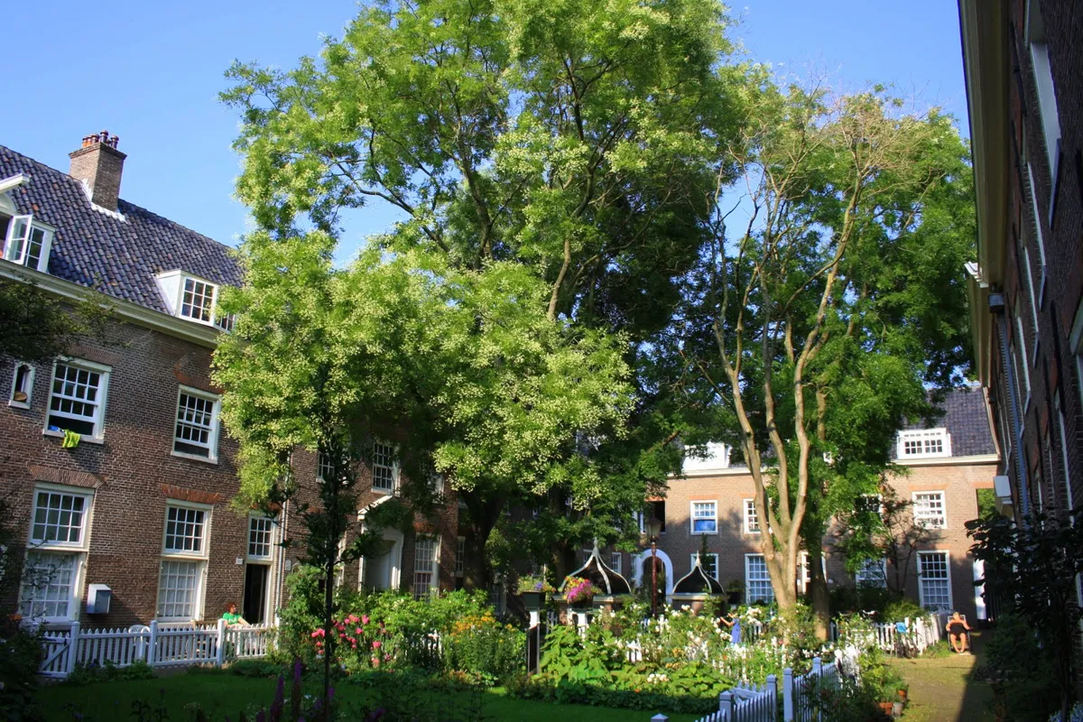
Inside the Karthuizerhof, with its two domed pumps. Photo: Eibert Draisma, CC BY-SA 3.0, via Wikimedia Commons (resized). Walk back east along the Bloemgracht and turn left up Tweede Leliedwarsstraat, over the Egelantiersgracht, and keep north. Turn right into Anjeliersstraat, left up Tweede Anjeliersdwarsstraat, straight on across the Westerstraat into Tichelstraat, and right into Karthuizersstraat. Look up at the long front on your right. The white wooden racks at the upper windows are for drying washing, which earned the street its nickname, Droogstokkenstraatje. They were not in the original design. Behind is the Huiszittenweduwenhof, known as the Karthuizerhof. A Carthusian monastery stood here from 1394 until it was wrecked in 1566. In 1649 the city bought the land, and its architect Daniël Stalpaert designed 104 small homes in four wings around a courtyard, for poor widows and older unmarried women. They lived rent-free and got 25 baskets of peat a year. The first moved in in 1650. People still live here: if the gate is open, step in quietly.
More history
In the courtyard are two 17th-century pumps with domed roofs and bronze spouts shaped like a fish head and a mask. The last elderly residents left in 1973, and the hofje was then squatted, with the city's permission. A renovation in 1986 turned the 104 homes into 65, now social housing.
Sources: Rijksmonumentenregister, Huiszittenweduwenhof; Wikipedia (nl), Huiszittenweduwenhof; I amsterdam, the Jordaan (hofjes).
-
The Noorderkerk and the Noordermarkt
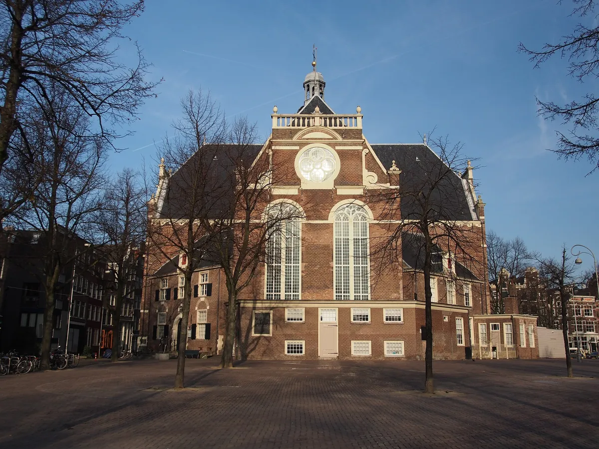
The Noorderkerk from the Noordermarkt. Photo: Alf van Beem, public domain, via Wikimedia Commons (resized). Walk east along Karthuizersstraat, turn right into Tweede Boomdwarsstraat and left into Boomstraat, and follow it to the Noordermarkt. The Noorderkerk was built for the fast-growing new district and held its first service on 16 April 1623. Hendrick de Keyser designed it too, and after his death his son Pieter and two city craftsmen finished it. Its plan is a Greek cross: four equal arms, with small houses tucked into the corners. It became the church of ordinary people, while the Westerkerk served mainly the middle and upper classes. The square, laid out in 1616, was mostly churchyard until 1655. A plaque on the church's south wall recalls the February Strike of 1941 against the deportation of Jews: the call to strike was made at banned meetings on this square. By the church door, a bronze by Sofie Hupkens remembers the Jordaan riot of 1934. Markets fill the square on Monday mornings and Saturdays, with an organic farmers' market on Saturdays.
More history
The 1934 riot broke out on 4 July, after the government cut benefits for the unemployed; police and army put it down, and five people died. In 1886 the Eel Riot on the nearby Lindengracht, which began when police tried to stop the banned game of eel-pulling, left 26 dead. On 10 June 1877 the young Vincent van Gogh heard a sermon here that impressed him. Since 1999 the church has held concerts every Saturday afternoon.
Sources: Wikipedia (nl), Noorderkerk; Wikipedia, Noorderkerk; Wikipedia (nl), Noordermarkt; Wikipedia, Noordermarkt; Wikipedia (nl), Jordaan; Noorderkerk. Market days: I amsterdam, Noordermarkt.
-
The Brouwersgracht, where the canal ring begins
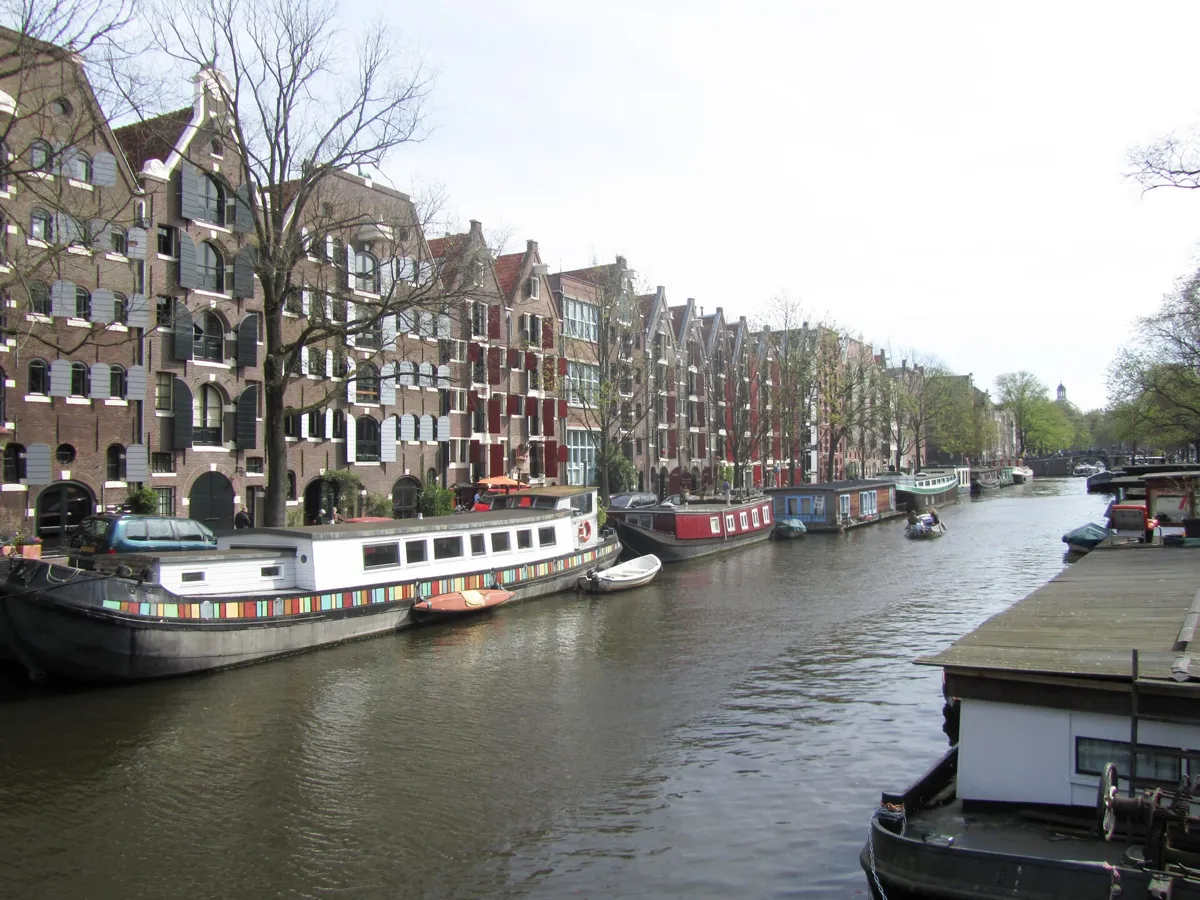
Warehouses along the Brouwersgracht. Photo: Jvhertum, public domain, via Wikimedia Commons (resized). Walk to the north end of the square and follow the Prinsengracht to its end, onto the Lekkeresluis bridge. Ahead is the Brouwersgracht, named in 1594 after the many breweries around it. From 1612 the canal ring was dug southwards from here, which is why the house numbers on the Singel, Herengracht, Keizersgracht, Prinsengracht and Lijnbaansgracht all start at this canal. To the west, it marks the Jordaan's northern edge. Look west along the right-hand bank: tall warehouses with big wooden shutters, built to store goods and now mostly homes. They have names: numbers 204 to 210 are Spitsbergen and three Green Deer. In 2007 readers of the newspaper Het Parool voted the Brouwersgracht Amsterdam's most beautiful street.
More history
Since 1782 De Ooievaar, the last jenever and liqueur distillery in Amsterdam, has stood on this canal by the Driehoekstraat. Numbers 158 to 162, the warehouses of a stockfish dealer, are named after the Norwegian ports Bergen, Tromsø and Hammerfest; he bought number 162 in 1888 and built the other two in 1891 and 1895.
Sources: Wikipedia (nl), Brouwersgracht; Wikipedia, Brouwersgracht.


,_Westerkerk_--_2015_--_7179.jpg)


Practical details
- Terrain
- Flat: Open-Meteo puts every stop between about 3 and 10 m above sea level. Canal-side streets and low bridges.
- Step-free
- OpenStreetMap maps no steps on the route. It marks the Koningsplein tram stop, 90 m from the start, and the Rokin metro entrance, about 200 m away, as wheelchair accessible.
- Water
- OpenStreetMap lists two Waternet tap-water points by the start at Spui: one 35 m away and another 76 m away. None further along, so fill up before you set off.
- Toilets
- OpenStreetMap shows a free public toilet by the Homomonument (not wheelchair accessible) and a paid, wheelchair-accessible Westerkerk WC by the church (stops 2 and 3).
- Sit and eat
- Cafés and restaurants line the Noordermarkt (stop 7), and the Nine Streets (stop 1) are full of small shops and restaurants.
- When to go
- The Westerkerk is open, free, on weekdays from 11:00 to 15:00, and also on Saturdays in July and August; it closes on some dates, so check its site. The Anne Frank House opens daily from 9:00 to 22:00, with shorter hours on a few days; tickets go on sale online every Tuesday at 10:00, for visits six weeks later. The Noordermarkt has markets on Monday mornings (9:00–14:00) and Saturdays (9:00–16:00).
- Shorter walk
- Skip the Nine Streets and start at the Homomonument, by the Westermarkt tram stop (13, 17): about 2 km and an hour.
- Getting back
- Amsterdam Centraal is about 950 m, 13 minutes on foot, from the Lekkeresluis.
Walking distances and times from the OSRM foot router on OpenStreetMap data. Elevations from Open-Meteo. Stations, fountains and toilets from OpenStreetMap; opening times from the Westerkerk, the Anne Frank House and I amsterdam. Checked 4 October 2026.
Questions people ask
How long does the Jordaan self-guided walking tour take, and is there a map?
About 80 minutes: 3.1 km, 41 minutes of walking and eight stops, from Spui to the Brouwersgracht, which is about 950 m (13 minutes) from Amsterdam Centraal. Allow more if you go inside the Westerkerk or the Anne Frank House. The map is on this page, and you can print it or save it as a PDF.
What is the Jordaan known for?
It was built from 1612 as a working-class district and is now one of the most expensive places to live in the Netherlands. People come for its narrow canals and side streets, its hofjes (almshouse courtyards), the carved gable stones on its houses, its art galleries and small shops, and its markets on the Noordermarkt, the Westerstraat and the Lindengracht.
Is the Anne Frank House in the Jordaan?
Just outside it. The Jordaan ends at the Prinsengracht, and the Anne Frank House stands on the canal's east bank at Prinsengracht 263, next to the Westerkerk. Tickets are sold only online, for a set time slot, and not at the door.
Can you visit the hofjes in the Jordaan?
Some, yes. The Jordaan had nineteen hofjes in 2017. Several are open to the public, but many are still lived in, so visitors are asked not to shout. On this walk you pass the Karthuizerhof of 1650; if its gate is open, step in quietly and keep to the path.
Why is it called the Jordaan?
Nobody knows for sure. When it was built it was called Het Nieuwe Werck, the New Work. The name Jordaan first appears in 1718, in a poem where it means the Prinsengracht. The likeliest explanation is that the canal was nicknamed after the river Jordan and the name passed to the district behind it. The popular story that it comes from the French jardin, garden, has no sources to back it.
Walk it with Strolio
Open Strolio at Spui and ask for an hour and a half through the Jordaan. Strolio builds walks in any city with mapped streets, so its route may pick different stops from this page. Stories play as you reach each place, and you can ask about anything else you pass, by voice or with a photo. You can also start from your hotel and choose your own time and interests.
More self-guided walks
- All Strolio walks: self-guided city walks with maps, every fact sourced.
- Madrid's Barrio de las Letras: about an hour, from Lope de Vega's church to the press that printed Don Quixote.
- Barcelona's Gothic Quarter and El Born: about 90 minutes, from Roman columns to the cathedral and El Call.
Sources
- Official and heritage sites, linked under each stop: Homomonument, Westerkerk, Anne Frank House, Noorderkerk, Hendrick de Keyser Monumenten, the Rijksmonumentenregister (Bloemgracht 87, Huiszittenweduwenhof), and I amsterdam on the Jordaan and the Noordermarkt. We used their facts and wrote our own text.
- Wikipedia (Dutch): Jordaan, De 9 Straatjes, Westerkerk, Anne Frank Huis, Bloemgracht, De Drie Hendricken, Huiszittenweduwenhof, Noorderkerk, Noordermarkt, Brouwersgracht
- Wikipedia (English): Jordaan, Negen Straatjes, Homomonument, Westerkerk, Anne Frank House, Bloemgracht, De Drie Hendricken, Noorderkerk, Noordermarkt, Brouwersgracht
- Map data and places: © OpenStreetMap contributors, ODbL; walking route from the OSRM foot router at routing.openstreetmap.de
- Elevations: Open-Meteo
- Photos: Wikimedia Commons contributors JayAmber, Hnapel, Dietmar Rabich, Massimo Catarinella, Spider, Eibert Draisma, Alf van Beem and Jvhertum, credited under each photo