
Porto Baixa self-guided walking tour · 1 hour · map
Porto's Baixa on foot: Avenida dos Aliados, the Bolhão market and the Capela das Almas
The Baixa is Porto's downtown: the granite avenue where the city celebrates, its market, its main shopping street and two churches wrapped in blue tiles. This one-hour walk starts at São Bento station and ends on Praça da Batalha, a few minutes from where you began.
Most of what you see here is newer than the riverside old town. The main square was laid out from 1718, outside the medieval walls. The Avenida dos Aliados, the city hall, the Bolhão market building and Café Majestic all went up between 1914 and the 1950s. The two tiled churches are older, but their famous tiles were added in 1929 and 1932. If you want Livraria Lello, the Clérigos tower, the cathedral and the Ribeira, take our historic centre walk; this one does not repeat it.
A note on accuracy: where a building was rebuilt, or where sources disagree on a date, we say so, and every fact links to its source.
- Start
- São Bento station (trains and metro line D)
- Finish
- Praça da Batalha, about 400 m from São Bento
- Distance
- 1.8 km, one way
- Time
- About an hour: 24 min walking and 7 stops, plus any time in the market or the Majestic
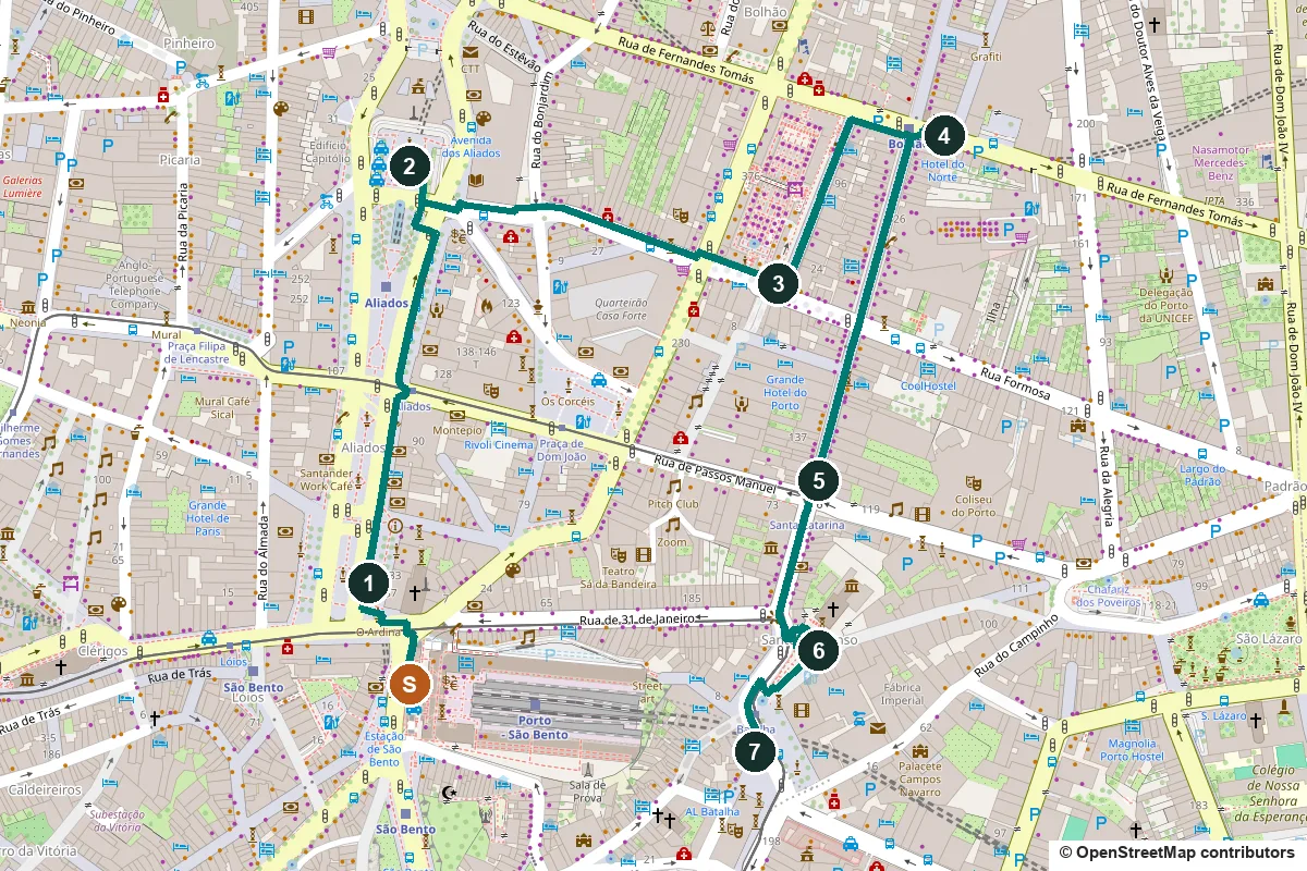
Terrain, water, opening days and a shorter version ↓
What to see: the stops
-
Praça da Liberdade and the statue of Pedro IV
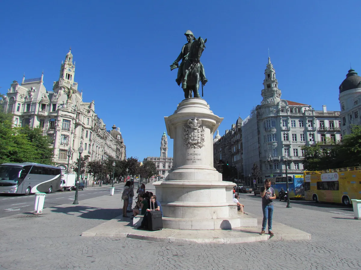
Pedro IV, with the Avenida dos Aliados behind. Photo: Marcio, CC BY 2.0, via Wikimedia Commons (resized). Leave São Bento by the main door and cross north into Praça da Liberdade. The square was laid out from 1718 on land given by the cathedral chapter, just outside the medieval wall, and was first called the Praça Nova, the New Square. It has changed names with the politics: Praça da Constituição in 1820, Praça de D. Pedro IV in 1833, and Praça da Liberdade since 27 October 1910. The bronze rider in the middle is Pedro IV, by the French sculptor Anatole Calmels, unveiled on 19 October 1866. He holds the Constitutional Charter of 1826 in his right hand. One relief on the base shows him giving his heart to Porto; it has been kept in the Lapa church since 1835. The long front on the south side, begun after 1788 as a convent on the line of the old wall, is the oldest building on the square and is now a hotel. On the east side, at number 126, look up at the bronze eagle over the McDonald's door. It belonged to the Café Imperial, which opened in 1936, and was made by the sculptor Henrique Moreira. McDonald's moved in in 1995 and kept the stained glass and crystal chandeliers.
More history
From 1819 to 1916 the city council met in a building on the north side of the square. By the mid-19th century the square was lined with cafés where politicians, journalists and merchants met; banks, insurers and offices later replaced them. The insurance building on the corner with the avenue, by José Marques da Silva, dates from 1919–1924.
Sources: Wikipedia (pt), Praça da Liberdade; Wikipedia, Liberdade Square; Wikipedia (pt), Monumento a D. Pedro IV; Wikipedia (pt), Igreja da Lapa; Observador, 26 August 2018; CEPESE, Os Paços do Concelho do Porto.
-
Avenida dos Aliados and the city hall
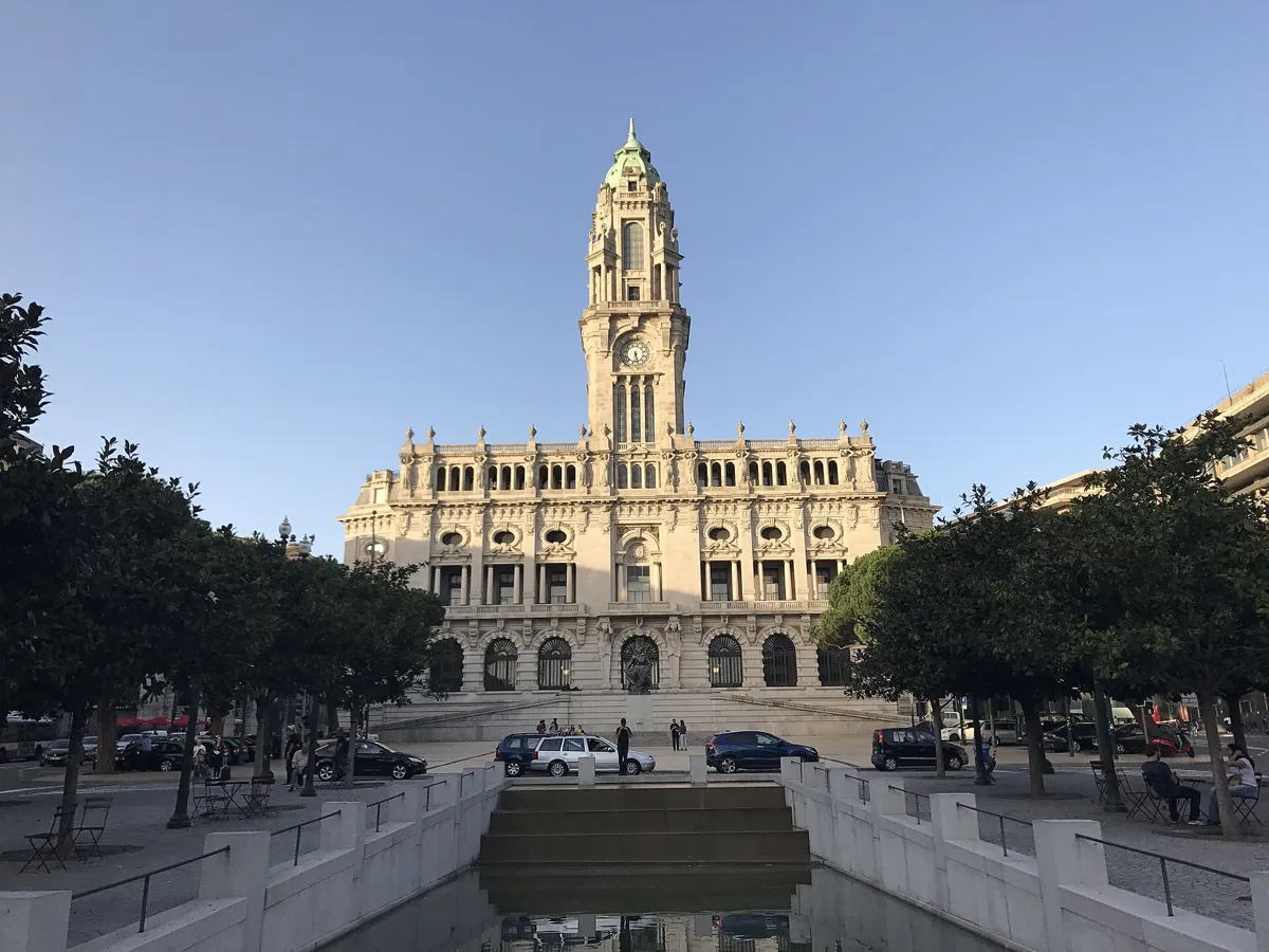
The city hall at the top of the avenue. Photo: -wuppertaler, CC BY-SA 4.0, via Wikimedia Commons (resized). Walk up the wide paved strip in the middle of the avenue to the city hall at the top. Until 1916 this was a tangle of short streets and alleys. Work began on 1 February 1916, with the President of the Republic, Bernardino Machado, watching the first stone of the old council house being taken down. The plan for the new civic centre was drawn by the English architect Barry Parker, and the avenue was named after the Allies of the First World War. The buildings are granite, many topped with domes and pinnacles. On the central strip, the statue of a girl known as the Menina dos Aliados is A Juventude (Youth), by Henrique Moreira, put here in 1929. The strip was a garden until 2006, when Álvaro Siza and Eduardo Souto de Moura repaved it in granite when the metro station was built below; many people objected. The city hall was begun in 1920 to a design by António Correia da Silva, changed by Carlos Ramos, and the council only moved in in 1957. Its tower is 70 m high, with a carillon clock and 180 steps inside. The dozen figures on the front, by José de Sousa Caldas and Henrique Moreira, show Porto's trades, from wine growing to shipping.
More history
Between 1916 and 1957 the council met in the bishop's palace by the cathedral. The avenue is where the city gathers to celebrate. Pope John Paul II said mass by the city hall on 15 May 1982, and Pope Benedict XVI on 14 May 2010, to a crowd of 120,000 to 150,000.
Sources: Wikipedia (pt), Avenida dos Aliados; Wikipedia (pt), Paços do Concelho do Porto; Visit Porto, Aliados Avenue; CEPESE, Os Paços do Concelho do Porto. Visits: Time Out, Paços do Concelho.
-
Mercado do Bolhão, the market that nearly disappeared
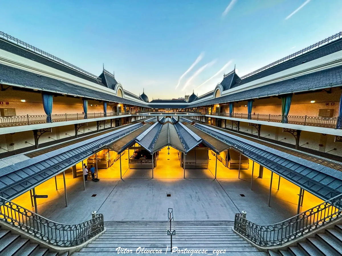
Inside the restored market, 2023. Photo: Vitor Oliveira, CC BY-SA 2.0, via Wikimedia Commons (resized). From the square in front of the city hall, take Rua de Guilherme da Costa Carvalho east, cross Rua de Sá da Bandeira and walk on to the market's main door on Rua Formosa. The market began in 1839, when the council bought land from the cathedral chapter: a wet meadow where a stream formed a bubble of water, a bolha, which gave the place its name. The present building, designed by the architect Correia da Silva, dates from 1914. It mixed reinforced concrete with iron frames, wooden roofs and granite, new for its time. It fills a whole block, and its four main doors open at different levels. After more than four years of building work, it reopened on 15 September 2022. The market says it now has 79 fresh-food stalls on the ground floor, 10 restaurants upstairs and 38 shops facing the street. Where possible the old tiles were saved. It opens Monday to Saturday and closes on Sundays and holidays.
More history
Serious faults in the floors were found in the mid-1980s, and a 1990s restoration plan by Joaquim Massena was approved but never built. In 2007 the council chose a private developer to run the market for up to 70 years, with luxury flats and a shopping centre and little room left for traders. Protests followed, including a petition with more than 50,000 signatures, and the deal collapsed in 2008. The council paid for the work itself; it officially started in May 2018.
Sources: Wikipedia (pt), Mercado do Bolhão; Mercado do Bolhão, about the market. Opening hours: Mercado do Bolhão, FAQs.
-
Capela das Almas, the chapel covered in 15,947 tiles
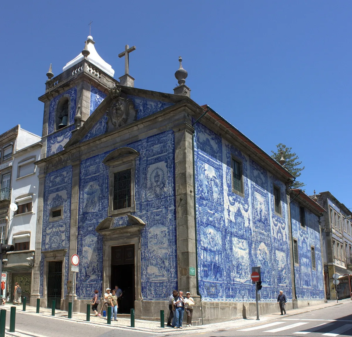
The chapel from the corner of Rua de Santa Catarina. Photo: Nelson Rocha, CC BY 2.0, via Wikimedia Commons (resized). Walk north up Rua de Alexandre Braga, along the market's east side, and turn right on Rua de Fernandes Tomás. The chapel stands on the corner with Rua de Santa Catarina. It is also called the Capela de Santa Catarina and began as a wooden chapel to St Catherine; the street is named after it. Sources date the present building differently: Visit Porto says the start of the 18th century, Wikipedia the end, when the Brotherhood of the Souls moved here from the Santa Clara monastery. It was enlarged in 1801. Until 1929 its outside walls were plain whitewashed plaster. That year they were covered with 15,947 tiles, about 360 square metres, designed by Eduardo Leite and made by the Viúva Lamego factory in Lisbon. The blue scenes show the lives of St Francis of Assisi and St Catherine, among them his death and her martyrdom. Entry is free; it is open on weekdays from early morning.
More history
The coat of arms over the door combines the arms of St Francis and St Catherine. In 1804 Pope Pius VII granted the chapel a weekly Thursday adoration. The tile panels were restored in 1982.
Sources: Wikipedia (pt), Capela das Almas; Wikipedia, Chapel of Santa Catarina; Wikipedia (pt), Rua de Santa Catarina. Opening hours: Visit Porto, Capela das Almas.
-
Café Majestic on Rua de Santa Catarina
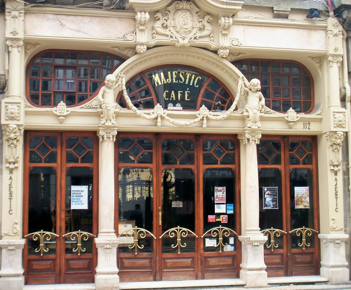
The front at Rua de Santa Catarina 112. Photo: AntoniusJ, public domain, via Wikimedia Commons (resized). Walk south down Rua de Santa Catarina, Porto's busiest shopping street and mostly closed to cars. On your right you pass the Grande Hotel do Porto, opened in 1880; the exiled Brazilian empress Teresa Cristina died there in 1889. Number 112, near the corner of Rua de Passos Manuel, is the Majestic. The café's own history says its owners formed their company on 17 December 1921, a date some sources give as the opening, and that it opened to the public on 2 December 1922. It names the architect as José Pinto de Oliveira; some sources credit João Queiroz, who designed the 1925 bar at the back. Look at the front: two carved children flank the name and seem to invite you in. Inside are carved wood, big mirrors, stucco faces and a winter garden at the back. The writers José Régio and Teixeira de Pascoaes and the philosopher Leonardo Coimbra were regulars, and later students and teachers from the fine arts school. It declined from the 1960s, was listed as a building of public interest and reopened after restoration on 15 July 1994. It opens Monday to Saturday.
More history
Visit Porto repeats a claim from a biography of J.K. Rowling that she spent long hours here working on the first Harry Potter book while she lived in Porto. On this street, in 1896, Aurélio Paz dos Reis filmed workers leaving the Confiança factory, which is counted as the first Portuguese film.
Sources: Café Majestic, history; Wikipedia (pt), Café Majestic; Visit Porto, Café Majestic; Wikipedia (pt), Grande Hotel do Porto; Wikipedia (pt), Rua de Santa Catarina. Opening hours: Café Majestic.
-
Santo Ildefonso, Jorge Colaço's tiled church
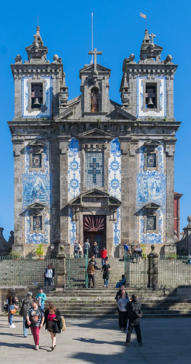
The church above its steps. Photo: Krzysztof Golik, CC BY-SA 4.0, via Wikimedia Commons (resized). Keep going along Rua de Santa Catarina to where it ends at Praça da Batalha; the church rises above its steps on your left. A chapel called Santo Alifon stood here by 1296. It was close to collapse by 1709, when it was pulled down and the new church begun. The date 1730 over the door marks the end of the first phase; the towers came next, and the church was blessed on 18 July 1739. No one knows who designed it. It is named after Ildefonsus, bishop of Toledo from 657 to 667. The front has about 11,000 tiles by Jorge Colaço, put up in November 1932, showing scenes from the saint's life and images of the Eucharist. Colaço also made the tiles in São Bento station's hall. Inside, the altarpiece was designed by the Italian artist Nicolau Nasoni. During the Siege of Porto, on 21 July 1833, the church was hit by artillery. Entry is free; there is also a small sacred art museum.
More history
The church needed heavy repairs after a storm in 1819. Its stained-glass windows were replaced in 1967 with new ones by Isolino Vaz. When the porch was renovated in 1996, nineteen graves from the old chapel's churchyard were found.
Sources: Wikipedia (pt), Igreja de Santo Ildefonso; Wikipedia, Church of Saint Ildefonso; Visit Porto, Igreja de Santo Ildefonso; Wikipedia (pt), Estação de São Bento. Museum: Visit Porto, Sacred Art Museum.
-
Praça da Batalha and the Teatro Nacional São João
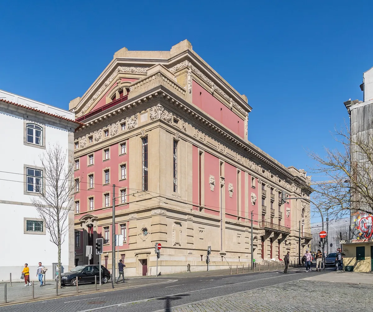
The Teatro Nacional São João. Photo: Krzysztof Golik, CC BY-SA 4.0, via Wikimedia Commons (resized). Go on into Praça da Batalha and cross to the theatre on its south side. The name means Battle Square: tradition says the people of Porto fought and lost a battle here against Almanzor's army in the 10th century. One of the gates of the medieval town wall stood at the square's south-west corner. The statue in the middle, of King Pedro V, has been here since 1866. The theatre replaces the Real Teatro de São João, designed by the Italian Vicente Mazzoneschi and opened on 13 May 1798 for the birthday of the future King João VI. The theatre says it was the first building in Porto made only for shows. Fire gutted it on the night of 11–12 April 1908. José Marques da Silva won the competition to rebuild it, and the new theatre opened on 7 March 1920. Four allegorical figures on the frieze stand for kindness, pain, hatred and love. For years it worked as a cinema; the state acquired it and reopened it as the national theatre on 28 November 1992. It is now a national monument.
More history
The palace with a coat of arms on the east side dates from the late 18th century. During the Siege of Porto its owners, who backed King Miguel, left, and the liberal government used it for offices and as a field hospital. Bernardo de Sá Nogueira, later Marquis of Sá da Bandeira, had his right arm amputated there. Also on the east side is the Cine-Teatro Batalha, a cinema of 1947 by Artur Andrade.
Sources: TNSJ, the building; TNSJ, history; Wikipedia (pt), Teatro Nacional São João; Wikipedia, São João National Theatre; Wikipedia (pt), Praça da Batalha; Visit Porto, Praça da Batalha.


Practical details
- Terrain
- The one real climb is up the Avenida dos Aliados to the city hall (stop 2). Open-Meteo puts the start about 35 m lower than the top of the avenue; after that the streets rise and fall only a little. Rua de Santa Catarina is mostly closed to cars.
- Step-free
- Not fully. OpenStreetMap maps steps right beside the route in front of Santo Ildefonso, a flight of six steps by the city hall, and more steps near the market. The Bolhão market says it has ten lifts inside. OpenStreetMap marks São Bento's train and metro stations as wheelchair accessible.
- Water
- OpenStreetMap shows no drinking fountains on the route. Carry water, or buy it in the market.
- Toilets
- OpenStreetMap maps free toilets inside the Bolhão market (stop 3) and paid toilets at São Bento station, open 7:00 to 22:30.
- Sit and eat
- The Bolhão market (stop 3) has food stalls and 10 restaurants upstairs, open Monday to Saturday. Café Majestic (stop 5) serves breakfast, lunch and tea.
- When to go
- Monday to Saturday. On Sundays the Bolhão market and Café Majestic are closed. The market opens Monday to Friday 8:00–20:00 and Saturday 8:00–18:00; the Majestic Monday to Saturday 9:00–23:00. The Capela das Almas and Santo Ildefonso open daily with shorter hours at weekends and close for part of the day; check Visit Porto.
- Shorter walk
- Finish at stop 4, the Capela das Almas: 1.1 km, about 35 minutes. Bolhão metro station is beside the chapel.
- Getting back
- São Bento station is about 380 m, 5 minutes on foot, west of Praça da Batalha.
Walking distances and times from the OSRM foot router on OpenStreetMap data. Elevations from Open-Meteo. Stations, steps, fountains and toilets from OpenStreetMap. Market, café and church hours from Mercado do Bolhão, Café Majestic and Visit Porto. Checked 5 October 2026.
Questions people ask
How long does this Porto self-guided walking tour take, and is there a map?
About an hour: 1.8 km, 24 minutes of walking and seven stops, from São Bento station to Praça da Batalha, about 400 m from São Bento again. Add time for coffee at the Majestic or shopping in the Bolhão market. The map is on this page, and you can print it or save it as a PDF.
Is the Bolhão market open on Sundays?
No. The market says it is closed on Sundays and public holidays. It opens Monday to Friday from 8:00 to 20:00 and on Saturday from 8:00 to 18:00; its restaurants open Monday to Saturday from 8:00 to midnight. Check before you go.
Is Café Majestic worth it?
Go for the room rather than a quick coffee: a 1920s Art Nouveau café with carved wood, large mirrors and stucco faces, restored and reopened in 1994. The front on Rua de Santa Catarina costs nothing to look at. It opens Monday to Saturday from 9:00 to 23:00 and is closed on Sundays.
Where are the best azulejo churches in Porto?
Two of the best-known tiled fronts are on this walk: the Capela das Almas on Rua de Santa Catarina, covered in 1929 with 15,947 tiles designed by Eduardo Leite, and the church of Santo Ildefonso on Praça da Batalha, with about 11,000 tiles by Jorge Colaço from 1932. Colaço also tiled the hall of São Bento station, which is on our historic centre walk.
Is Porto City Hall open to visitors?
It is the working town hall, not a museum, so you see it mostly from the outside. A 2017 Time Out listing mentioned occasional guided tours, but we could not find a current schedule, so ask the city council before you plan around a visit.
Walk it with Strolio
Open Strolio at São Bento station and ask for an hour through the Baixa. Strolio builds walks in any city with mapped streets, so its route may pick different stops from this page. Stories play as you reach each place, and you can ask about anything else you pass, by voice or with a photo. You can also start from your hotel and choose your own time and interests.
More walks in Porto
- Downhill to the river: ~90 min, 8 stops. From Livraria Lello and the Clérigos tower past the medieval synagogue site and São Bento's tiles to the Ribeira and the Luís I bridge.
- Vila Nova de Gaia: ~90 min, 8 stops. Cross the Douro to the port wine lodges and rabelo boats, climb to the round church of Serra do Pilar and walk back over the bridge's top deck.
- Along the river to Foz: ~2½ h, 8 stops. From the Miragaia customs house past the Crystal Palace gardens and the Arrábida Bridge to the lighthouse at the sea.
- All Porto walks, with maps side by side.
- Walks in other cities.
Sources
- Official sites: Mercado do Bolhão (hours), Café Majestic, history, Teatro Nacional São João (history). We used their facts and wrote our own text.
- Visit Porto (Porto city council): Aliados Avenue, Capela das Almas, Café Majestic, Igreja de Santo Ildefonso, Sacred Art Museum, Praça da Batalha
- CEPESE, Os Paços do Concelho do Porto (2012), published with Porto city council
- Wikipedia (Portuguese): Praça da Liberdade, Monumento a D. Pedro IV, Igreja da Lapa, Avenida dos Aliados, Paços do Concelho do Porto, Mercado do Bolhão, Capela das Almas, Rua de Santa Catarina, Grande Hotel do Porto, Café Majestic, Igreja de Santo Ildefonso, Praça da Batalha, Teatro Nacional São João, Estação de São Bento
- Wikipedia (English): Liberdade Square, Chapel of Santa Catarina, Church of Saint Ildefonso, São João National Theatre
- Press: Observador on the McDonald's Imperial (2018); Time Out on the Paços do Concelho (2017)
- Elevations: Open-Meteo
- Map data and places: © OpenStreetMap contributors, ODbL; walking route from the OSRM foot router at routing.openstreetmap.de
- Photos: Wikimedia Commons contributors Marcio, -wuppertaler, Vitor Oliveira, Nelson Rocha, AntoniusJ and Krzysztof Golik, credited under each photo