
Royal Mile self-guided walking tour · 1½ hours · map
From Greyfriars Bobby to Holyrood: Edinburgh's Old Town and the Royal Mile on foot
Edinburgh's Old Town hangs off one ridge, with the castle at the top and a royal palace at the bottom. This walk starts with a famous dog in a graveyard, drops down Victoria Street to the Grassmarket, climbs to the castle and then follows the Royal Mile downhill to Holyrood.
The Royal Mile is a chain of streets running almost exactly a mile from the castle to the Palace of Holyroodhouse. The name is fairly new: it came into use in the early 20th century. The ridge it follows is the tail of glacial debris left behind the castle's volcanic crag, so the street slopes steadily down to the east, with steep alleys, called closes, dropping off both sides between tall tenements.
A note on accuracy: some of the Old Town's best-loved stories are legends, and some buildings are not what their names suggest. Where a story is disputed or a building is not the original, we say so, and every fact links to its source. The walk itself is free; the castle, the palace, Gladstone's Land and St Giles' charge for going inside.
- Start
- Greyfriars Bobby's statue, at the corner of George IV Bridge and Candlemaker Row
- Finish
- The gates of the Palace of Holyroodhouse, at the foot of the Canongate, opposite the Scottish Parliament
- Distance
- 2.6 km, one way
- Time
- About 1½ hours: 34 min walking and 8 stops, plus any visit inside the castle or the palace
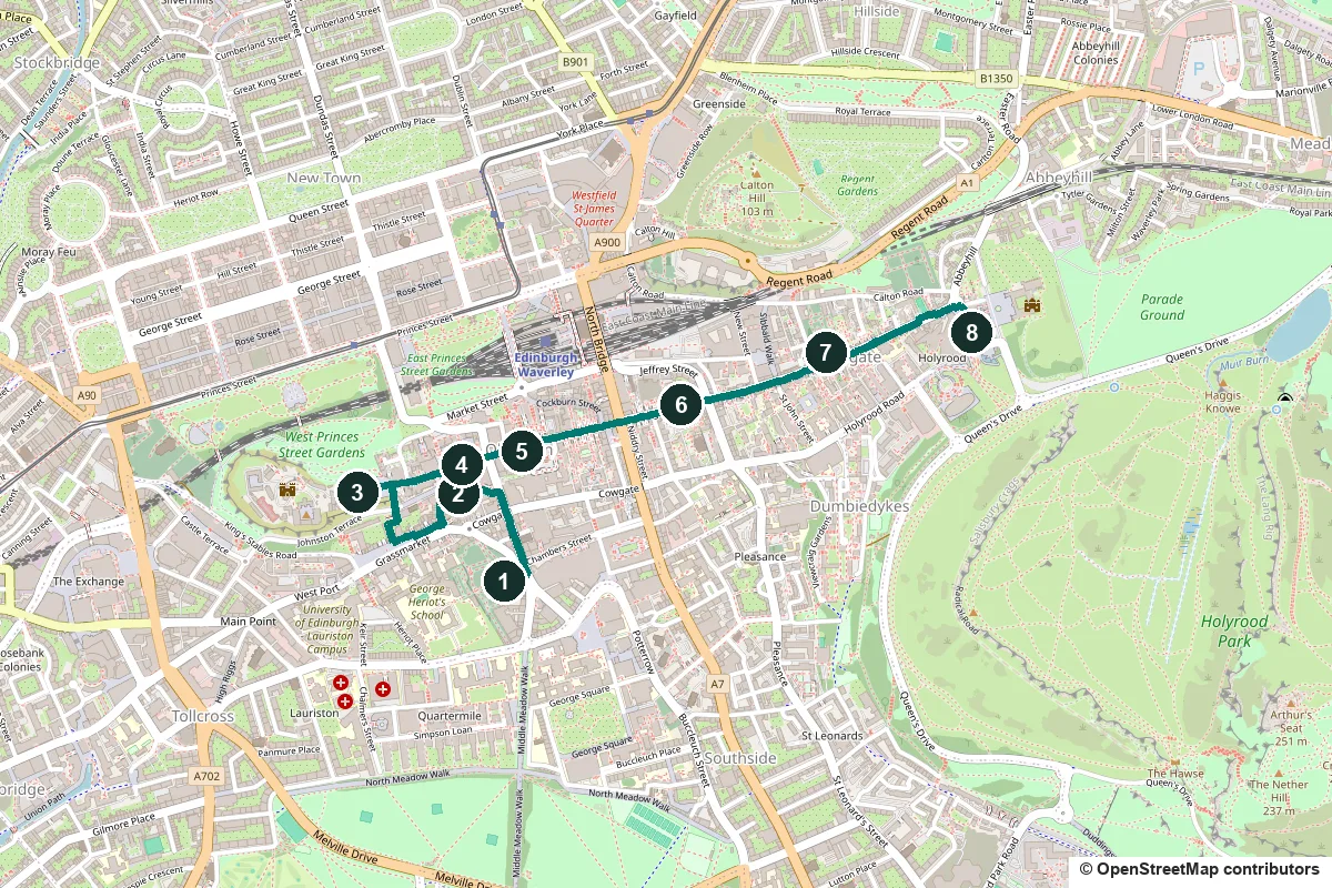
Terrain, steps, water, opening times and a shorter version ↓
What to see: the stops
-
Greyfriars Kirkyard and Greyfriars Bobby
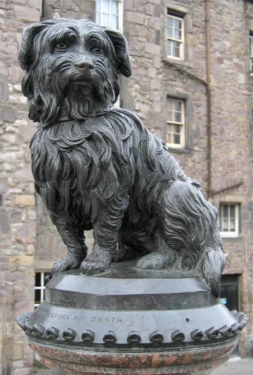
Greyfriars Bobby on his fountain. Photo: Michael Reeve, CC BY-SA 3.0, via Wikimedia Commons. Start at the little bronze terrier on a drinking fountain where Candlemaker Row meets George IV Bridge. Bobby is said to have guarded his master's grave for 14 years, until he died on 14 January 1872. In the best-known version the master was John Gray, a police nightwatchman who died in 1858. Baroness Burdett-Coutts paid for the fountain, with a statue by William Brodie. The story's accuracy has been challenged many times, and one author argues Bobby was a stray "graveyard dog" fed by visitors. Cross into the kirkyard, where Bobby's headstone, put up in 1981, stands just inside the gate. In 1562 Mary, Queen of Scots gave the grounds of a Franciscan friary here to the town for burials, and the church, finished in 1620, was the first built in Edinburgh after the Reformation. Harry Potter fans come for the grave of Thomas Riddell, who died in 1806. Many believe J. K. Rowling borrowed the name for Tom Riddle, Lord Voldemort, but that is fans' belief, not confirmed fact. So many people visit that the council has reported serious erosion around the grave.
More history
The National Covenant was signed at Greyfriars in 1638. Two iron cages called mortsafes survive: they were leased out in the early 19th century to protect fresh graves from body snatchers, who supplied corpses to the medical college.
Rowling wrote early drafts in Edinburgh cafés, most famously the Elephant House on George IV Bridge, which reopened in December 2025 after a fire in 2021.
Sources: Wikipedia, Greyfriars Bobby; Wikipedia, Greyfriars Kirkyard; Wikipedia, Greyfriars Kirk; Greyfriars Kirk, The National Covenant; Edinburgh Evening News; Forever Edinburgh, Harry Potter guide; Forever Edinburgh, Tales from beyond the grave. Visiting: the Greyfriars Kirk site.
-
Victoria Street and the Grassmarket
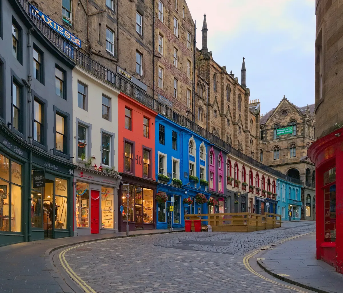
Victoria Street early in the morning; Victoria Terrace runs along the railings above the shops. Photo: Daniel Kraft, CC BY-SA 3.0, via Wikimedia Commons (resized). Walk north up George IV Bridge and turn left down Victoria Street. Until after 1827 the way down here was the West Bow, a steep Z-shaped lane from the Grassmarket up to the foot of Castlehill. Under the Improvement Act of that year, the architect Thomas Hamilton laid out George IV Bridge and this new link to the Grassmarket; Victoria Street was new in 1840. Most of the old houses were swept away, though Hamilton drew them first. The railed walk above the shops on your right is Victoria Terrace, a pavement built on their roofs. Many Harry Potter fans think the street inspired Diagon Alley, but again that is belief, not fact. At the bottom, the Grassmarket opens out under the castle rock. It was one of Edinburgh's main market places from 1477, and a place of public hangings. Near its east end, a memorial of 1937 remembers more than 100 Covenanters hanged between 1661 and 1688, beside a gibbet's shadow set in dark paving.
More history
Five old houses survive at the foot of the West Bow, among them Crocket's Land, built around 1705. In 1724 Maggie Dickson was hanged here, but was found alive in her coffin on the way home. She could not be hanged twice for the same crime, so she went free. A pub here bears her name.
Sources: Historic Environment Scotland, 95–99 West Bow; HES, Crocket's Land; HES, 87 West Bow; HES, Victoria Terrace; Forever Edinburgh; Wikipedia, Grassmarket.
-
The Castle Esplanade, at the gate of Edinburgh Castle
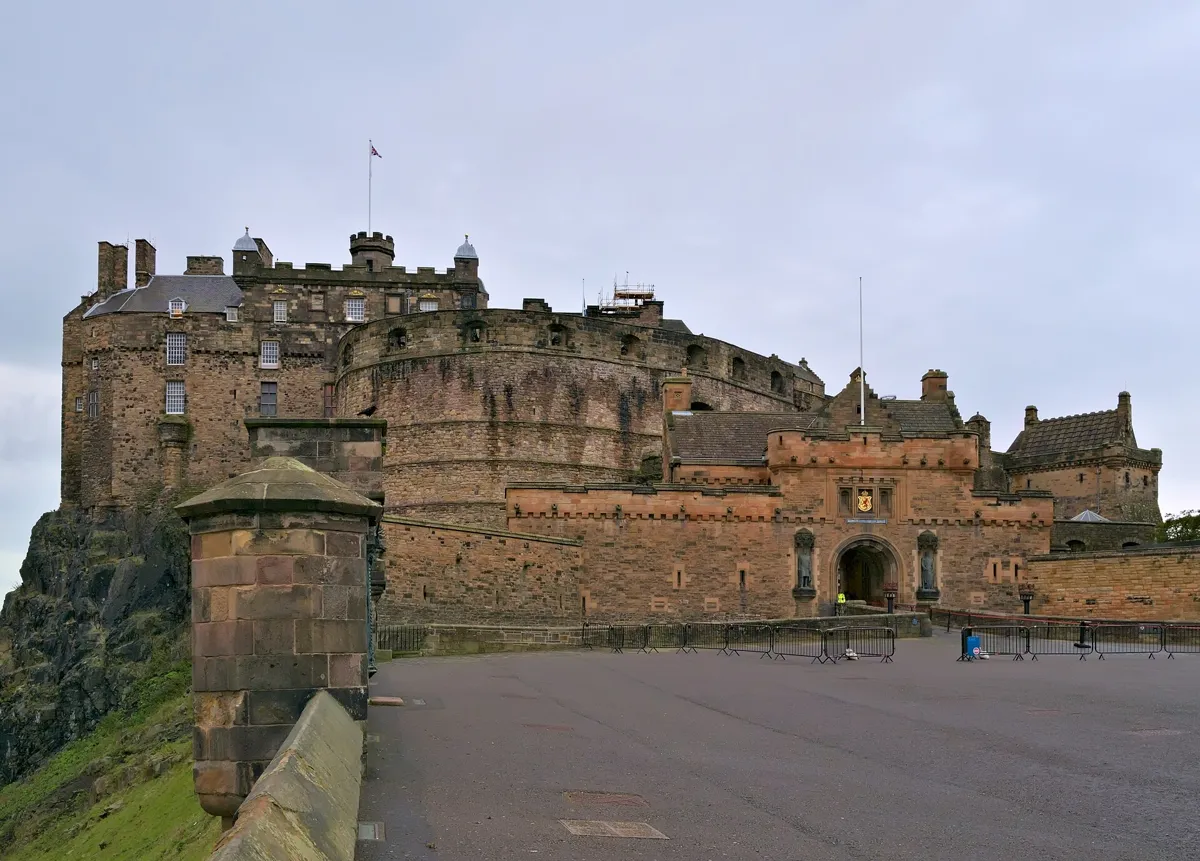
The castle from the Esplanade, with the gatehouse on the right. Photo: Daniel Kraft, CC BY-SA 3.0, via Wikimedia Commons (resized). At the Grassmarket, turn right up the steps of Castle Wynd South, cross Johnston Terrace and climb Castle Wynd North to Castlehill, then turn left onto the Esplanade. This forecourt was laid out as a parade ground in 1753, partly with spoil from building the Royal Exchange, now the City Chambers. The Royal Edinburgh Military Tattoo is staged here every August, and its stands are in place from May to October. Ahead are the round Half Moon Battery and, to its left, the Royal Palace. There has been a royal castle on this rock since the 11th century, and its oldest building, St Margaret's Chapel, dates from around 1130. Going inside needs a ticket from Historic Environment Scotland, and summer tickets often sell out. Heading back down, the first building on your right is Cannonball House. Its cannonball was not fired from the castle, as people often say: it marks the height of the springs that fed a cistern on Castlehill, one of Scotland's first piped water supplies.
More history
Research in 2014 counted 26 sieges of the castle. The One O'Clock Gun, a time signal for ships since 1861, fires at 1 pm every day except Sundays and a few holidays, such as Christmas Day. In 1818 Walter Scott broke into a sealed room in the castle and found the Honours of Scotland, the crown jewels, thought lost since the union with England in 1707.
Sources: Wikipedia, Edinburgh Castle; Wikipedia, Royal Mile; Historic Environment Scotland, Edinburgh Castle. Visiting: hours and tickets on HES's plan-your-visit page.
-
Gladstone's Land, a merchant's six-storey tenement
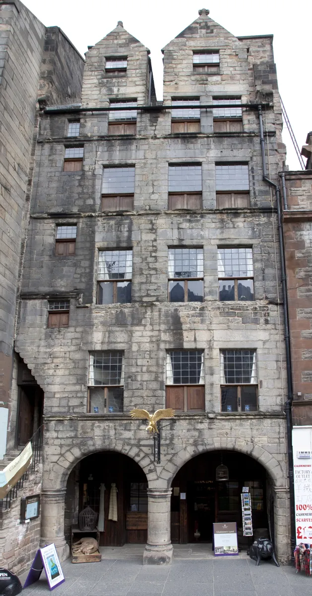
Gladstone's Land on the Lawnmarket, with the gilded hawk over the arcade. Photo: Tony Hisgett, CC BY 2.0, via Wikimedia Commons (resized). Walk down Castlehill into the Lawnmarket. A charter of 1477 made this stretch the market for cloth, yarn and similar goods, and it was called the Land Market. Gladstone's Land is on your left. In 1617 the merchant Thomas Gledstanes and his wife, Bessie Cunningham, bought an older house here and rebuilt it with a stone front and an arcaded shop; their initials, TG and BC, are carved at the foot of the gables. The plot was narrow, so the house could only grow up and back, to six storeys. The gilded hawk is a later addition that plays on the name: "gled" is Scots for a kite or hawk. Condemned in 1934, the building was saved by the National Trust for Scotland, and restoration uncovered painted ceilings from around 1620. It is now a museum, with an ice-cream parlour and coffee shop downstairs.
More history
By the late 18th century the cramped Old Town was out of fashion, and the well-off moved to the New Town across the valley. Gladstone's Land closed from 2020 to 2021 for a £1.5 million restoration.
Sources: Historic Environment Scotland, Gladstone's Land; Wikipedia, Gladstone's Land; Wikipedia, Royal Mile. Visiting: hours and prices on the National Trust for Scotland's page.
-
St Giles' Cathedral, the Heart of Midlothian and the Mercat Cross
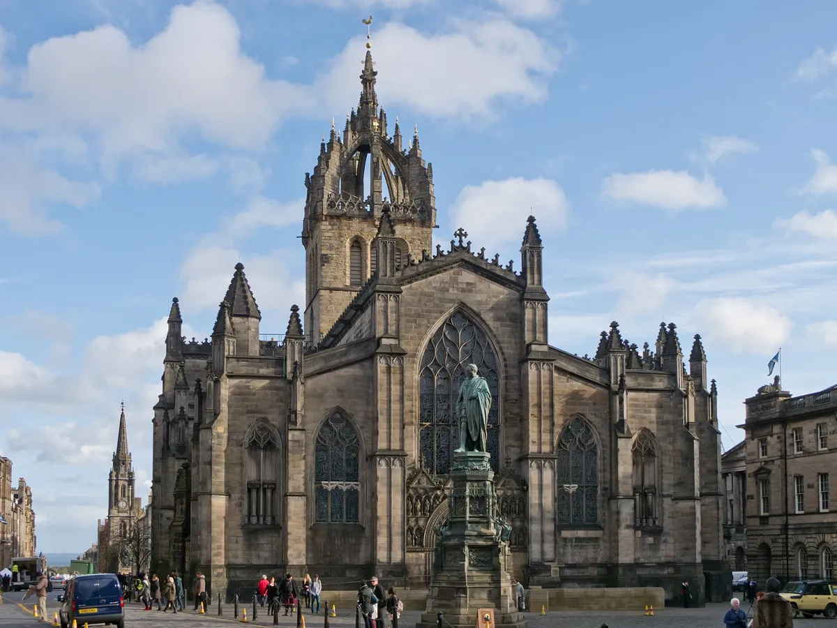
St Giles' and its crown steeple from the west. Photo: Carlos Delgado, CC BY-SA 3.0, via Wikimedia Commons (resized). Keep going down the Lawnmarket, across the junction with George IV Bridge and Bank Street. St Giles' is on your right. By its west door, look down for a heart in the cobbles: the Heart of Midlothian. It marks the entrance of the Old Tolbooth, which over more than 400 years housed the town council, early meetings of the Scottish Parliament and the town jail, and from 1785 its gallows. It was pulled down in 1817, and Walter Scott named his 1818 novel after it. Locals have long spat on the heart in contempt for the old jail. St Giles' was probably founded in the 12th century; the present church was begun in the 14th, and its crown steeple dates from 1460–67. John Knox became its minister in 1559. Despite the name, it was a cathedral only in 1633–38 and 1661–89. Visitors aged 16 and over who don't live in Scotland pay to go in. At the east end stands the Mercat Cross, a Victorian rebuild near the old site, paid for by William Gladstone in 1885. Heralds still proclaim a new monarch from it.
More history
In 1637 a new prayer book, modelled on the Church of England's, set off a riot here; tradition says a market trader, Jenny Geddes, threw her stool at the dean. The riot led to the National Covenant. On the south side, Parliament House held the Parliament of Scotland until 1707. Across the street, the City Chambers were built as the Royal Exchange in 1754–61.
Sources: Wikipedia, St Giles' Cathedral; Wikipedia, Old Tolbooth; Wikipedia, Mercat Cross; Wikipedia, Parliament Square; Wikipedia, Royal Mile. Visiting: tickets and hours on St Giles' Cathedral's site.
-
John Knox House and the old town gate
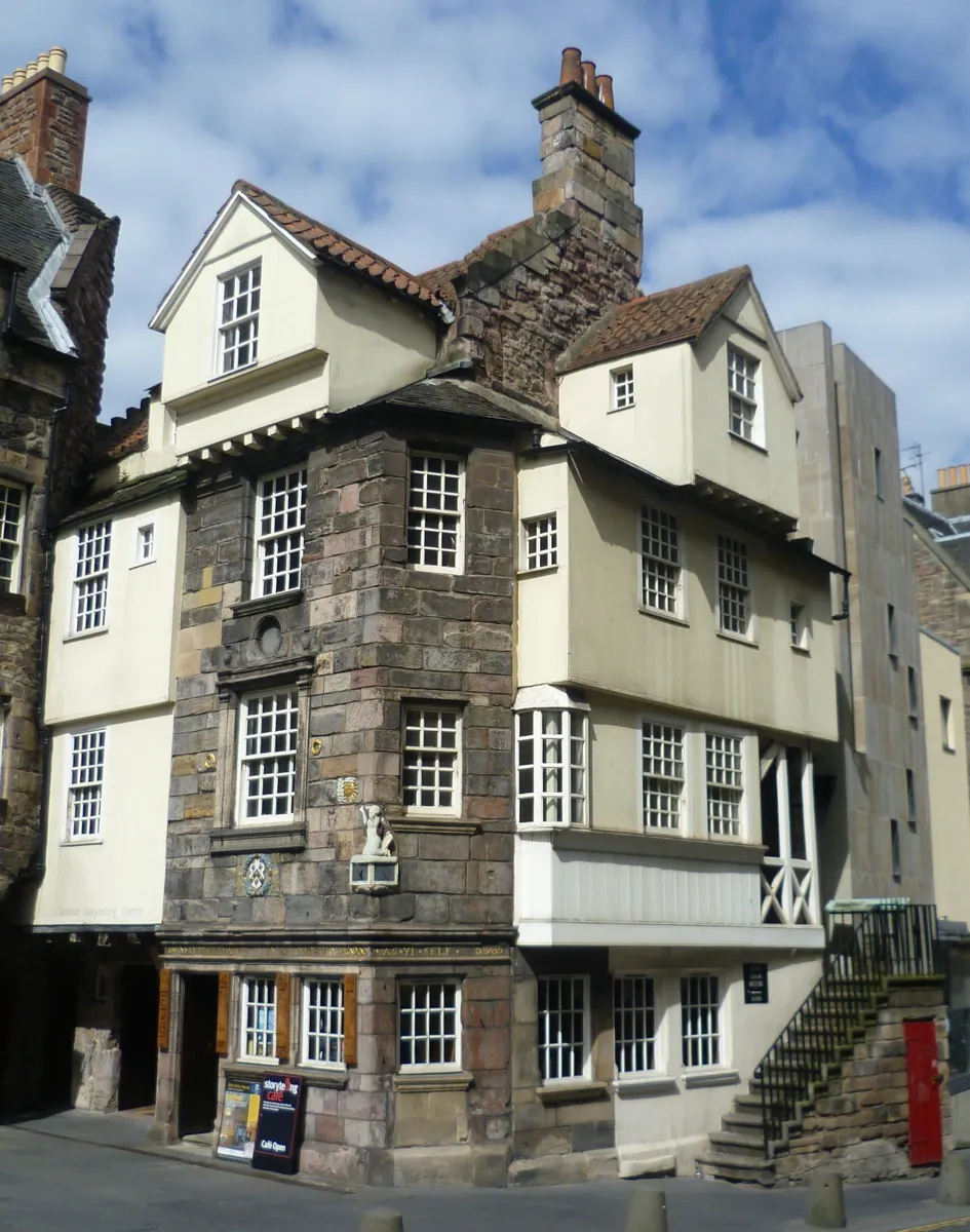
John Knox House on the High Street. Photo: Kim Traynor, CC BY-SA 3.0, via Wikimedia Commons (resized). Carry on down the High Street, across the North Bridge crossroads, to where the street narrows. The jutting old house on your left is John Knox House. Parts of it date from the late 15th century, and its ground-floor stone stalls, once open to the street, are the only medieval shops left in Scotland. Did Knox live here? Tradition has said so since about 1800, but he seems to have lived in Warriston Close, further up the street, where a plaque marks the approximate site. From 1556 the house belonged to Mariota Arres and her husband, James Mossman, goldsmith to Mary, Queen of Scots; their initials and arms are on the front. Mossman minted coins for the queen's party holding the castle, and in 1573 he was hanged for counterfeiting. The Knox legend helped save the house from demolition three times, and it has been a museum since 1853. At the crossroads just below, brass studs in the road mark the Netherbow Port, the town gate into the separate burgh of the Canongate, removed in 1764.
More history
The carved figure by the sundial is Moses, though it is often taken for Knox. The old Scots inscription on the front reads, in modern spelling, "Love God above all and thy neighbour as thyself". The World's End pub on the corner is named after World's End Close, the last close in Edinburgh before the Canongate.
Sources: Historic Environment Scotland, John Knox House; Wikipedia, John Knox House; Wikipedia, Royal Mile; Wikipedia, Edinburgh town walls.
-
Canongate Kirk and Adam Smith's grave
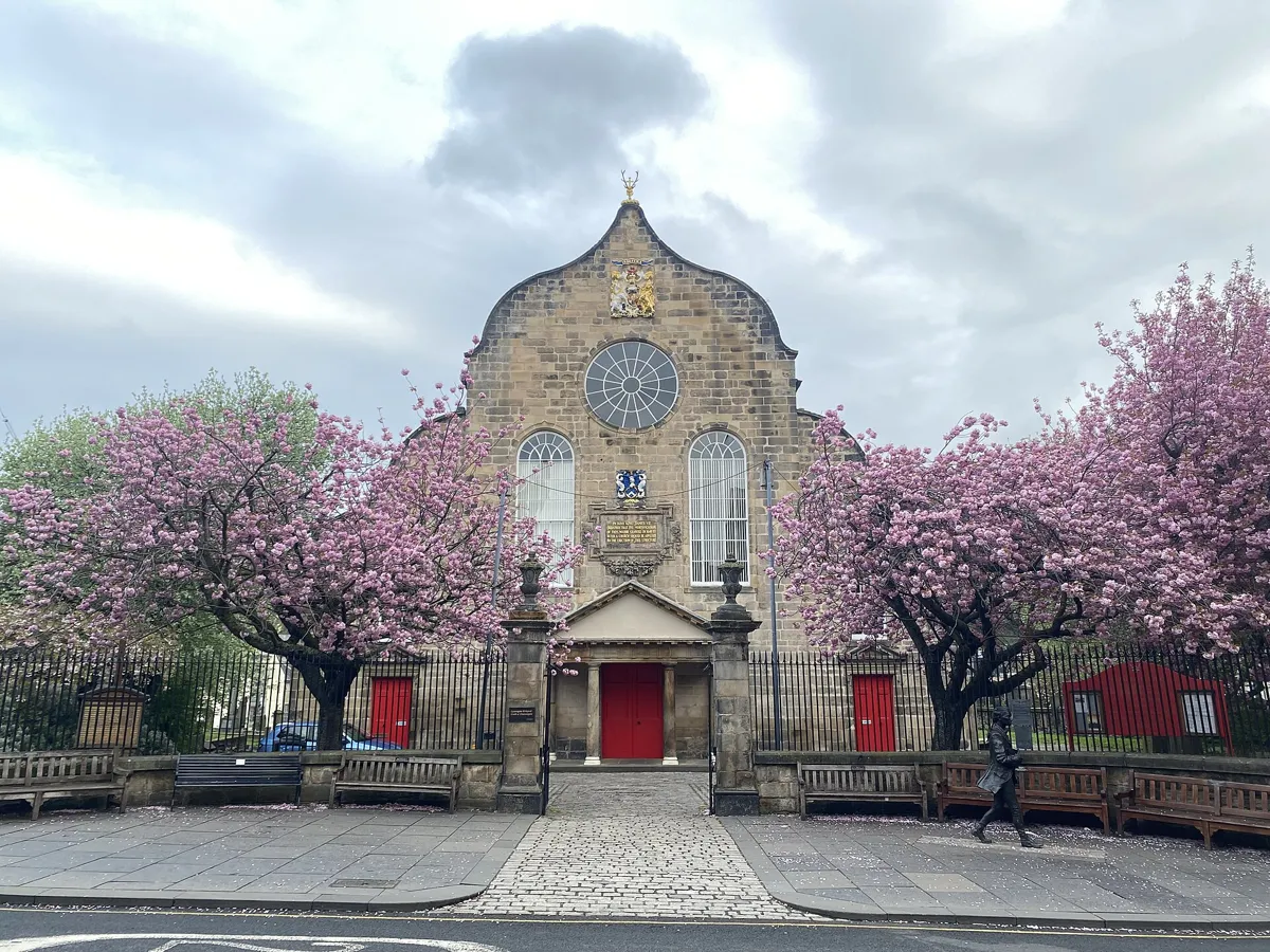
Canongate Kirk, with Robert Fergusson's statue on the pavement at the right. Photo: 瑞丽江的河水, CC BY-SA 4.0, via Wikimedia Commons (resized). Cross into the Canongate, "the canons' way", named after the canons of Holyrood Abbey; until 1856 this was a separate burgh. Past the Canongate Tolbooth, now The People's Story museum, the kirk stands back on your left behind a low curved wall. It exists because of a king: in 1687 James VII turned Holyrood Abbey, where this parish worshipped, into a Catholic chapel for the Order of the Thistle. James Smith designed the new church, finished in 1691, with a curved Dutch-style gable and a cross-shaped plan thought to be unique among Scottish churches of the 17th century. On top, a gold cross sits inside a pair of antlers, the old arms of the Canongate; the antlers there now came from a stag shot at Balmoral by King George VI and went up in 1949. In the kirkyard lies Adam Smith, author of The Wealth of Nations, who lived nearby, at the head of Panmure Close, from 1778 until his death in 1790.
More history
The bronze young man striding along the pavement is the poet Robert Fergusson, by David Annand, unveiled in 2004. Fergusson died in 1774, aged 24, and is buried here; Robert Burns, inspired by his poems, paid for the headstone. Agnes Maclehose, the "Clarinda" of Burns's letters, lies here too.
Sources: Historic Environment Scotland, Canongate Parish Church; Wikipedia, Canongate Kirk; Wikipedia, Canongate Kirkyard; Wikipedia, Robert Fergusson; Wikipedia, Royal Mile.
-
Holyrood: the Scottish Parliament and the Palace of Holyroodhouse
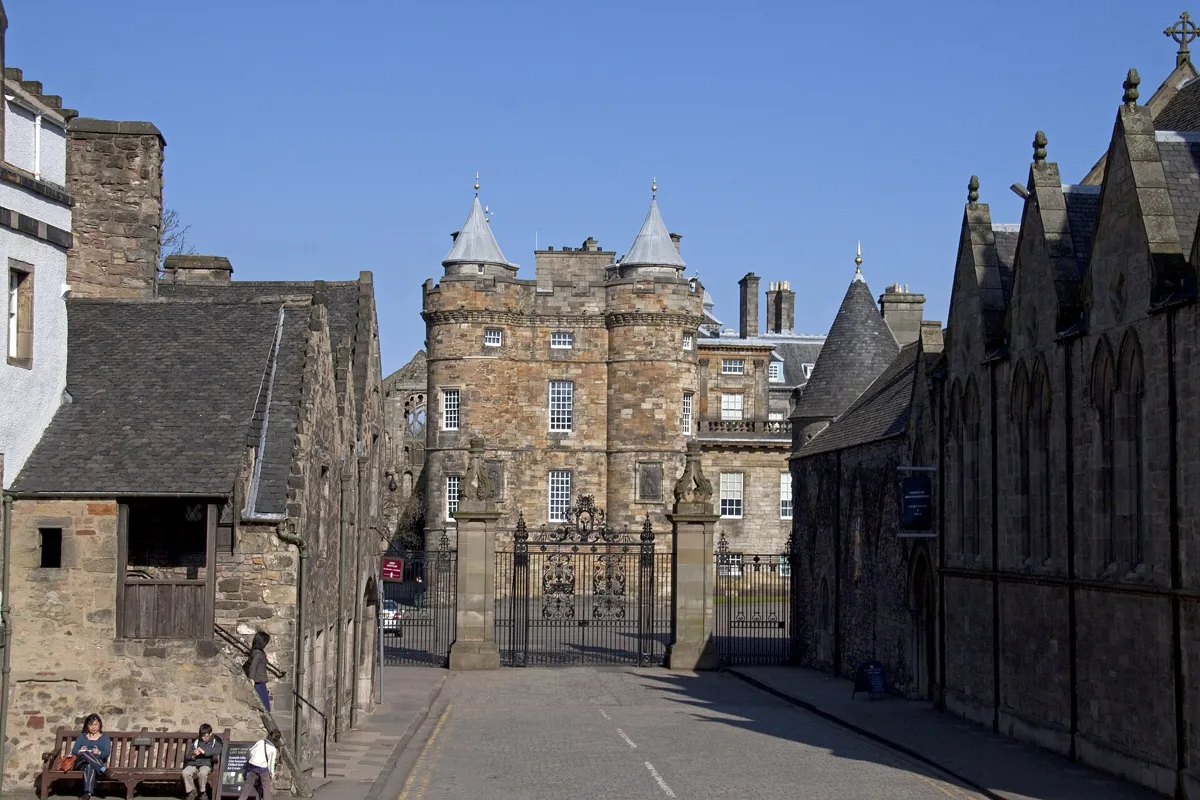
The palace gates and James V's tower from Abbey Strand. Photo: Tony Hisgett, CC BY 2.0, via Wikimedia Commons (resized). Walk on to the foot of the Canongate. On your right is the Scottish Parliament, designed by the Spanish architect Enric Miralles, who died before it was finished. Queen Elizabeth II opened it on 9 October 2004, more than three years late. Its final cost, about £414 million, was many times the first estimates, yet it won the 2005 Stirling Prize. Visiting it is free. Ahead, through Abbey Strand, are the gates of the Palace of Holyroodhouse, the King's official home in Scotland. Sir William Bruce designed most of it, built in 1671–78, but the turreted tower on the left is James V's, from the 16th century. Mary, Queen of Scots lived there from 1561 to 1567, and her secretary David Rizzio was stabbed in her rooms. Beside the palace are the ruins of Holyrood Abbey, founded in 1128 by David I. The palace is open to visitors with a ticket, except when the royal family is in residence.
More history
From 1999 to 2004 the Parliament met in the Church of Scotland's Assembly Hall, which you passed on Castlehill. The original lintel from Parliament House, beside St Giles', was set above the new debating chamber.
Sources: Wikipedia, Scottish Parliament Building; Wikipedia, Holyrood Palace; Royal Collection Trust, Palace of Holyroodhouse. Visiting: Scottish Parliament opening times.


.jpg)


.jpg)
Practical details
- Terrain
- One real climb. From the Grassmarket you go up about 160 steps (OpenStreetMap's count) in three flights: Castle Wynd South, the Patrick Geddes Steps and Castle Wynd North. After the castle it is downhill all the way: Open-Meteo puts Victoria Street and the Esplanade at about 98 m above sea level and Holyrood at 42 m. Expect cobbles (setts) on Victoria Street and parts of the Royal Mile.
- Step-free
- Skip the Grassmarket: from Victoria Street, go back up to George IV Bridge and walk west along the Lawnmarket and Castlehill to the Esplanade. That is just over 500 m, all by street. Inside, the castle has a steep cobbled route and some steps; Gladstone's Land's museum floors are up a steep spiral stair; St Giles' is step-free from its west door, but its Thistle Chapel is not.
- Water
- OpenStreetMap lists free Scottish Water "Top Up Tap" bottle refills in the Grassmarket, at the foot of the Castle Wynd steps; on the High Street, about 100 m past St Giles'; and by the Scottish Parliament at the finish.
- Toilets
- OpenStreetMap shows free public toilets by the Castle Esplanade, marked wheelchair accessible, and beside Holyrood Palace at the end. The Café at the Palace has accessible toilets you can use without a palace ticket.
- Sit and eat
- The Grassmarket (stop 2) is lined with pubs and cafés, many with pavement tables. Gladstone's Land (stop 4) has an ice-cream parlour and coffee shop on the ground floor, and the Café at the Palace is at the finish.
- When to go
- Greyfriars Kirkyard is open 24 hours. The castle opens daily from 9.30 am, closing at 6 pm from April to September and 5 pm from October to March, with last entry an hour before; it is closed on 25 and 26 December. St Giles' opens Monday to Friday 10 am to 6 pm, Saturday 9 am to 5 pm and Sunday 1 pm to 5 pm. The Scottish Parliament opens every day except Sunday and is closed to the public from 9 to 12 October 2026. Gladstone's Land and the palace: check their sites before you go.
- Shorter walk
- Finish at stop 5, St Giles': 1.3 km, 17 minutes of walking, about 50 minutes in all. Edinburgh Waverley station is about 450 m away, down the hill to the north.
- Getting back
- Edinburgh Waverley station is about 1.1 km, 15 minutes on foot, from the palace gates. Lothian Buses run through the Old Town, and the Greyfriars Kirk site lists services 2, 9, 23, 27, 35 and 45 near the start.
Walking distances and times from the OSRM foot router on OpenStreetMap data. Elevations from Open-Meteo. Stations, fountains and toilets from OpenStreetMap; opening times from Historic Environment Scotland, the National Trust for Scotland, St Giles' Cathedral, the Scottish Parliament and the Royal Collection Trust. Checked 4 October 2026.
Questions people ask
How long does it take to walk the Royal Mile?
From the Castle Esplanade to the gates of Holyrood Palace our route is 1.7 km, about 23 minutes of walking without stops. This whole walk, starting at Greyfriars and including Victoria Street and the Grassmarket, is 2.6 km with 34 minutes of walking; with eight stops, allow about an hour and a half, more if you go inside the castle or the palace. The map is on this page, and you can print it or save it as a PDF.
Why is it called the Royal Mile, and how long is it?
It runs between two royal places, Edinburgh Castle and the Palace of Holyroodhouse, and is almost exactly one mile long. The name only came into use in the early 20th century. It is a chain of streets: the Castle Esplanade, Castlehill, the Lawnmarket, the High Street, the Canongate and Abbey Strand.
Is the Royal Mile uphill?
Yes, from the bottom. It runs along a ridge from about 109 m above sea level at the castle down to 42 m at the palace, an average slope of about 4%. This walk does the climbing early, up about 160 steps from the Grassmarket to Castlehill, and then goes downhill all the way to Holyrood.
What is the Heart of Midlothian on the Royal Mile?
A heart shape set into the paving by the west door of St Giles' Cathedral. It marks the entrance of the Old Tolbooth, the town's council house and jail, which was pulled down in 1817. Walter Scott called the prison the Heart of Midlothian and used that as the title of his 1818 novel. Locals have long spat on the heart to show contempt for the old prison.
Is Greyfriars Kirkyard linked to Harry Potter?
Only by belief. The kirkyard holds the grave of Thomas Riddell, who died in 1806, and many fans think J. K. Rowling took the name of Tom Riddle, Lord Voldemort, from it, though the spelling differs. The sources we found report this as a belief, not a fact. Fans also point to a William McGonagall and an Elizabeth Moodie buried here. So many people visit Riddell's grave that the council has reported serious erosion around it.
Walk it with Strolio
Open Strolio at Greyfriars Bobby and ask for an hour and a half through the Old Town and down the Royal Mile. Strolio builds walks in any city with mapped streets, so its route may pick different stops from this page. Stories play as you reach each place, and you can ask about anything else you pass, by voice or with a photo. You can also start from your hotel and choose your own time and interests.
More self-guided walks
- All Strolio walks: every self-guided walk with a map, city by city.
- Madrid's Barrio de las Letras: about an hour, from Lope de Vega's church to the press that printed Don Quixote.
- Barcelona's Gothic Quarter and El Born: about 90 minutes, from Roman columns to the cathedral and El Call.
Sources
- Historic Environment Scotland, listed building records: 95–99 West Bow, Crocket's Land, 87 West Bow, Victoria Terrace, Gladstone's Land, John Knox House, Canongate Parish Church. We used their facts and wrote our own text.
- Wikipedia (English): Royal Mile, Greyfriars Bobby, Greyfriars Kirkyard, Greyfriars Kirk, Grassmarket, Edinburgh Castle, Gladstone's Land, St Giles' Cathedral, Old Tolbooth, Mercat Cross, Parliament Square, John Knox House, Edinburgh town walls, Canongate Kirk, Canongate Kirkyard, Robert Fergusson, Scottish Parliament Building, Holyrood Palace
- Harry Potter links: Edinburgh Evening News, Forever Edinburgh, The Ultimate Harry Potter Guide to Edinburgh, Forever Edinburgh, Tales from beyond the grave
- Opening times and visits: Historic Environment Scotland, Edinburgh Castle, National Trust for Scotland, Gladstone's Land, St Giles' Cathedral, Scottish Parliament, Royal Collection Trust, Palace of Holyroodhouse, Greyfriars Kirk
- Map data and places: © OpenStreetMap contributors, ODbL; walking route from the OSRM foot router at routing.openstreetmap.de
- Elevations: Open-Meteo
- Photos: Wikimedia Commons contributors Michael Reeve, Daniel Kraft, Tony Hisgett, Carlos Delgado, Kim Traynor and 瑞丽江的河水, credited under each photo