
Berlin Wall self-guided walking tour · 1½ hours · map
Where the Wall stood: a walk from the Reichstag to Checkpoint Charlie
For 28 years the Berlin Wall ran through the heart of Berlin. This 90-minute walk follows its line from the Reichstag past the Brandenburg Gate and Potsdamer Platz to Checkpoint Charlie, and stops at the few pieces still standing.
The Wall went up from 13 August 1961 and was opened on 9 November 1989. It ran for 155 km around West Berlin, 43 km of it between the city's two halves. The Berlin Wall Foundation counts at least 140 people who were killed at the Wall or died in connection with the border regime between 1961 and 1989. Its demolition began in June 1990, and little of it survives. In the centre, a double row of cobbles set into the street now marks its line, with metal strips reading "Berliner Mauer 1961–1989".
A note on accuracy: some stops are reconstructions or mark the site of something that has gone. Where that is the case, we say so, and every fact links to its source.
- Start
- Bundestag U-Bahn station (U5), just north-west of the Reichstag
- Finish
- Checkpoint Charlie on Friedrichstraße, about 100 m from Kochstraße U-Bahn (U6)
- Distance
- 4.0 km, one way
- Time
- About 1½ hours: 53 min walking and 8 stops, plus any museum visit
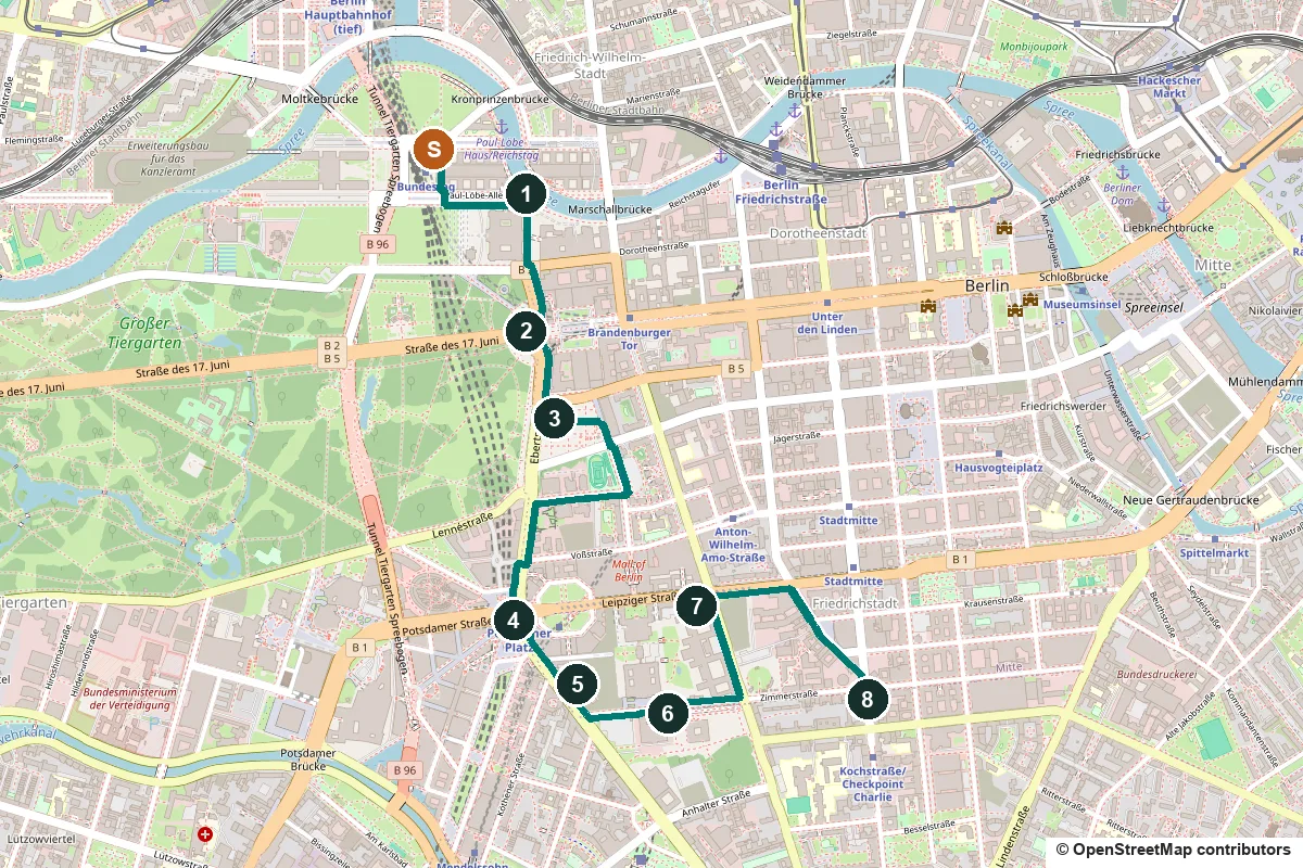
Terrain, water, opening hours and a shorter version ↓
What to see: the stops
-
The Reichstag and the White Crosses on the Spree
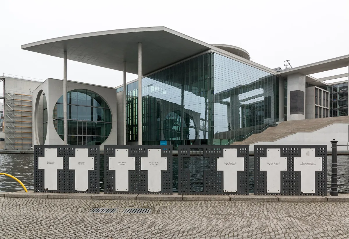
The White Crosses on the Spree bank. Photo: Dietmar Rabich, CC BY-SA 4.0, via Wikimedia Commons (resized). From Bundestag station, come up onto Platz der Republik in front of the Reichstag's west front, then walk round the building's north side to the river behind it. Built from 1884 to 1894 and home to the Bundestag since 1999, the Reichstag stood in the British sector, and the Wall ran right along its east side. Here the bank was West Berlin but the water was East Berlin. A citizens' group put up white crosses where the border wall met the river on 13 August 1971, ten years after the Wall was built. After building work moved them, seven crosses came back on 17 June 2003, with names on both sides. Günter Litfin, shot on 24 August 1961, was the first refugee killed by targeted fire after the Wall went up; Chris Gueffroy, killed on 5 February 1989, was the last to be shot dead at the border.
More history
The crosses first stood where each person died, but the citizens' group could not look after so many, so it gathered them here. One name, Klaus Schröter, was shot in this stretch of the Spree, between the Marschallbrücke and the Reichstag, on 4 November 1963. The Reichstag's dedication, "Dem deutschen Volke" (To the German people), was only put up in December 1916, in letters cast from two captured cannon.
Sources: Stiftung Berliner Mauer, White Crosses; Wikipedia (de), Weiße Kreuze; Wikipedia (de), Reichstagsgebäude; Wikipedia (de), Günter Litfin; visitBerlin, Where the Wall used to be. Visiting the dome: German Bundestag.
-
The Brandenburg Gate, shut in by the Wall for 28 years
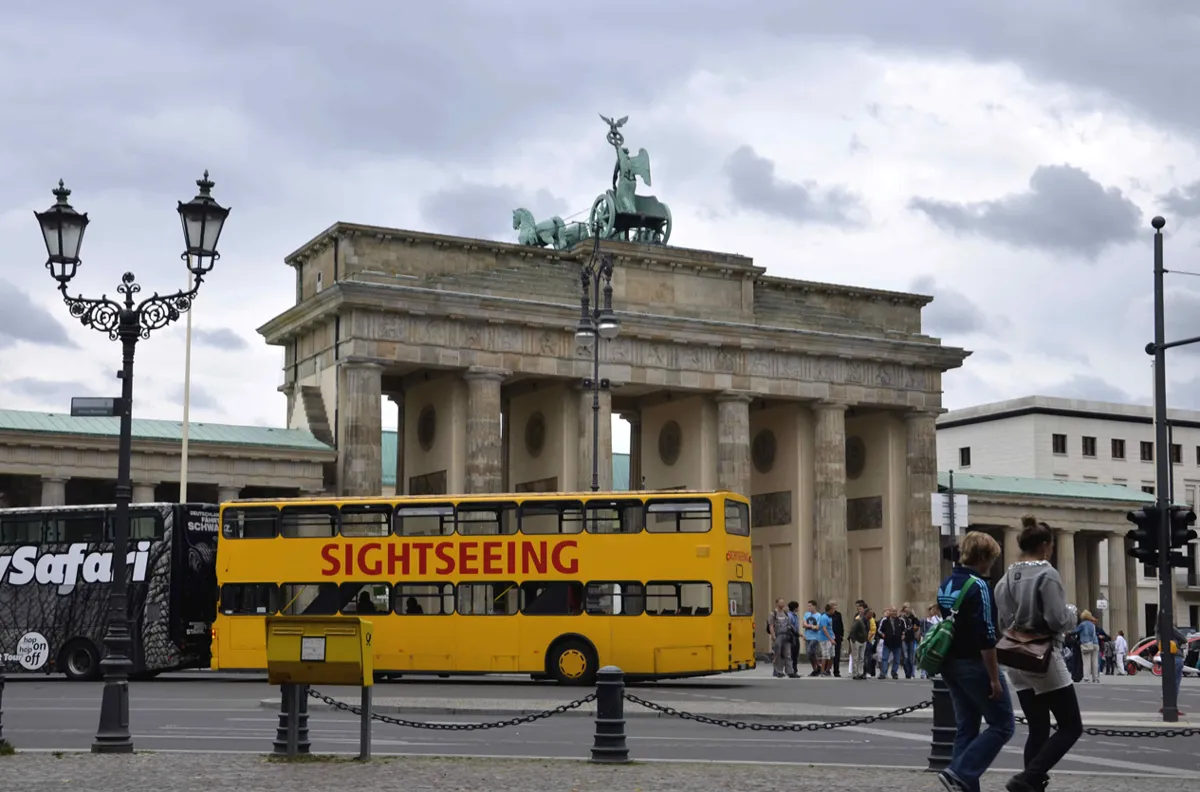
The gate's west side, which faced the Wall. Photo: T.Voekler, CC BY-SA 3.0, via Wikimedia Commons (resized). Walk south down Ebertstraße to the open square in front of the gate's west side, Platz des 18. März. Carl Gotthard Langhans designed the gate, which opened in 1791; it is the only one left of Berlin's last 18 city gates. From the day after the Wall went up, nobody could pass through. The Wall ran right along its west side; here it was a lower but especially thick barrier, built to stop tanks. Look down: a double row of cobbles traces its curve across the square. On 12 June 1987 Ronald Reagan spoke here to West Berliners: "Mr. Gorbachev, tear down this wall!" On 22 December 1989 the gate reopened, when Chancellor Helmut Kohl walked through to be greeted by the East German prime minister, Hans Modrow.
More history
Napoleon took the chariot on top, the Quadriga, to Paris in 1806; it came back in 1814. In the Second World War it was almost destroyed: one horse's head survives, in the Märkisches Museum. East and West Berlin worked together on the repairs, and a new Quadriga, made from plaster casts taken in 1942, went up in 1958. East Berlin removed its Iron Cross and eagle. They were put back after the Wall fell.
Sources: Stiftung Berliner Mauer, Brandenburg Gate; Wikipedia (de), Brandenburger Tor; Wikipedia, Brandenburg Gate.
-
The Memorial to the Murdered Jews of Europe, on the old death strip
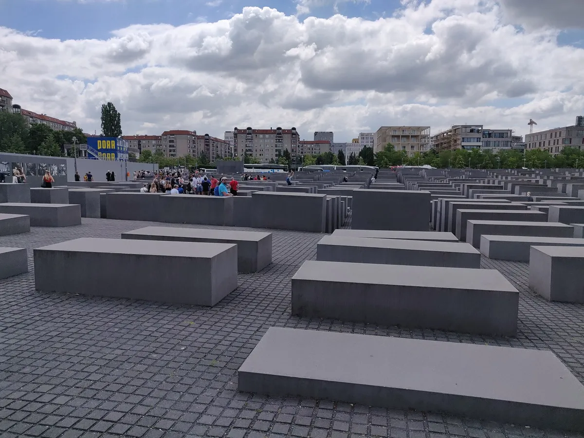
The field of stelae. Photo: Kurt Kaiser, CC0, via Wikimedia Commons (resized). Continue south along Ebertstraße. After Behrenstraße, the memorial fills the block on your left. It is Germany's central memorial to the up to six million Jewish victims of the Holocaust, and it opened on 10 May 2005. Peter Eisenman designed its field of 2,711 concrete blocks, or stelae, on 19,000 square metres of sloping ground. They rise from ground level to 4.7 metres, and the paths between them are 95 cm wide, so you walk them alone. From 1961 to 1989 this ground lay in the death strip, directly behind the Wall. Before that, Joseph Goebbels' villa stood here; its bunker turned up during the building work and was sealed back into the ground. The field is always open and free; the Information Centre underneath opens Tuesday to Sunday.
More history
The idea came from the journalist Lea Rosh in 1988, who first wanted the memorial on the former Gestapo site, which you pass at stop 6. After the Wall fell, the campaigners proposed this site instead. The plan was for about 4,000 stelae; the number was later cut to 2,711, which the memorial foundation says has no symbolic meaning.
Sources: Stiftung Denkmal für die ermordeten Juden Europas; Wikipedia (de), Denkmal für die ermordeten Juden Europas; Wikipedia, Memorial to the Murdered Jews of Europe.
-
Potsdamer Platz and its traffic-light tower
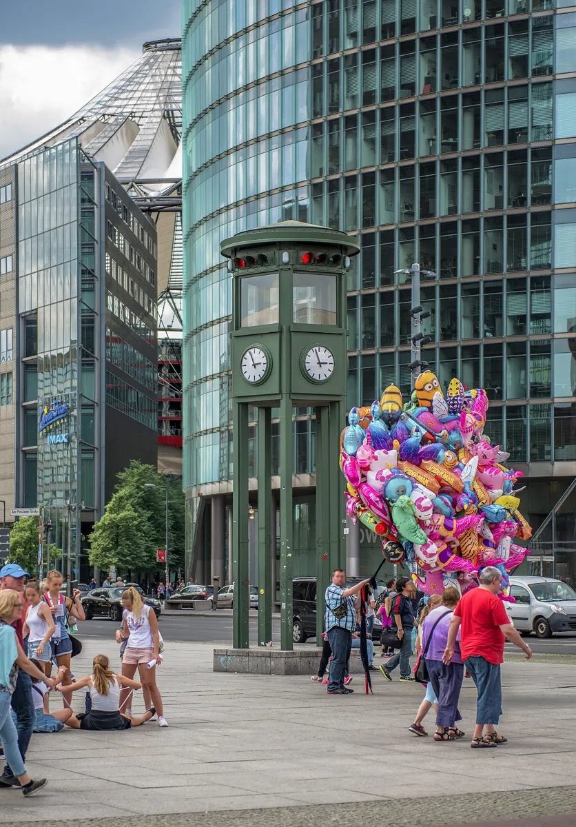
The 1997 copy of the 1924 traffic tower. Photo: Marek Śliwecki, CC BY-SA 4.0, via Wikimedia Commons (resized). Leave the memorial at its south-east corner and walk down Gertrud-Kolmar-Straße. At the corner of In den Ministergärten, an information board marks where Hitler's bunker lay. Nothing of it can be seen: the site is a car park, and the board went up in 2006 to counter the myths. Turn right to Ebertstraße and left to Potsdamer Platz, in the 1920s the busiest traffic junction in Europe. In 1924 Germany's first traffic light went up here: a five-sided tower in which a policeman switched the lights. The green tower you see is a full-size copy, commissioned in 1997 by Siemens and Daimler-Benz; it changes colour but controls nothing. From August 1961 the Wall cut across the square, and almost every building around it was pulled down. Nowhere else were the front wall and the inner wall so far apart. A few days after 9 November 1989 a piece was removed to open a crossing here.
More history
While the Wall stood, the square was wasteland, with platforms from which visitors looked over into the East. On 21 July 1990 Roger Waters staged The Wall on the empty ground nearby. In the 1990s Potsdamer Platz was the biggest inner-city building site in Europe. Cobbles here mark both the front wall and the inner wall, so you can see how wide the strip was.
Sources: Wikipedia (de), Verkehrsturm am Potsdamer Platz; Wikipedia (de), Potsdamer Platz; Wikipedia, Potsdamer Platz; Wikipedia, Berlin Wall. On the way: Wikipedia, Führerbunker; Wikipedia (de), Führerbunker.
-
Leipziger Platz and the last watchtower of its kind
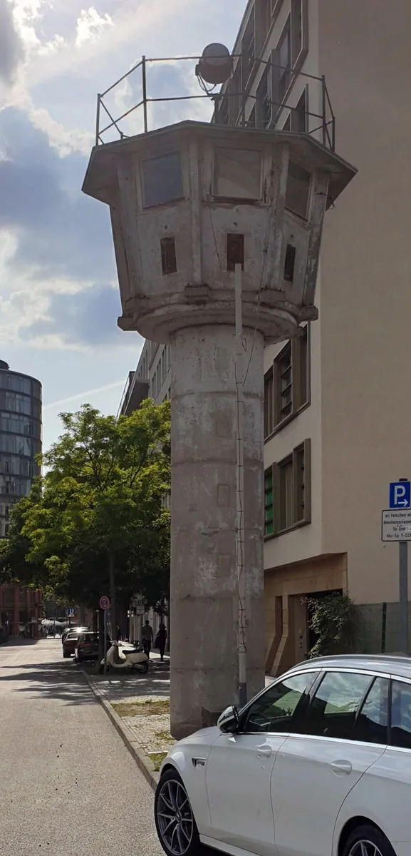
The watchtower on Erna-Berger-Straße. Photo: OTFW, Berlin, CC BY-SA 3.0, via Wikimedia Commons (resized). Look east into the eight-sided Leipziger Platz: several wall segments stand on its north and south sides. They come from the inner wall, the one facing East Berlin. So that the border looked neat to people on the western viewing platform, this inner wall was built from the same smooth slabs as the front wall. Now walk south-east down Stresemannstraße. At the corner of Erna-Berger-Straße is the last piece of inner wall in its original place; since 2013 it has been part of the Federal Environment Ministry's foyer. Turn left to the watchtower. This round type, with two iron ladders inside up to the cabin, was used from 1966. About 200 stood on the Berlin border; this is the only one left. It was moved eight metres east during building work in the late 1990s.
More history
From 1972 the narrow round towers were joined by roomier square ones: the slim shaft was not very stable and slowed soldiers down when they had to get out fast. This tower stood outside the death strip and watched the maze of ground towards the ministry buildings. It and the Leipziger Platz segments have been listed monuments since 2001.
Sources: Landesdenkmalamt Berlin, Leipziger Platz; Landesdenkmalamt Berlin, Wachturm Erna-Berger-Straße.
-
Niederkirchnerstraße: 200 metres of the real Wall
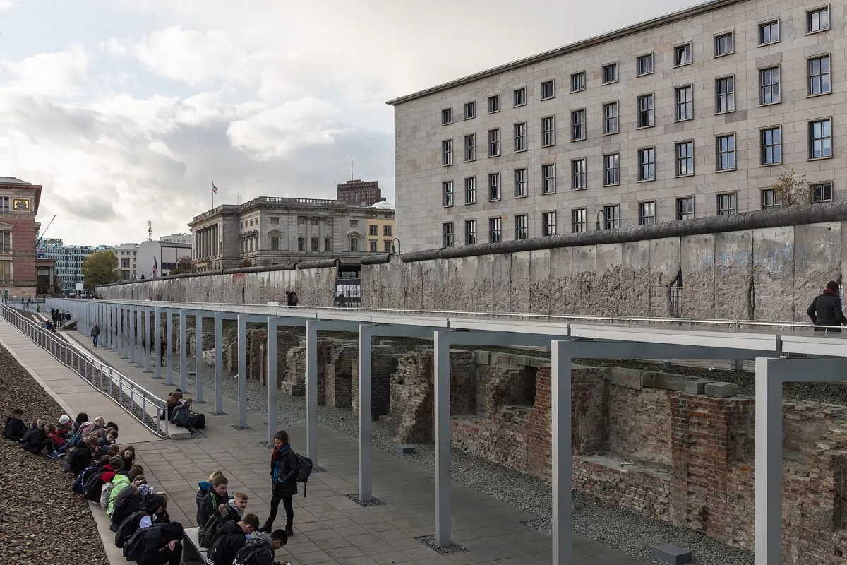
The Wall on Niederkirchnerstraße, above the Topography of Terror's trench. Photo: Pymouss, CC BY-SA 4.0, via Wikimedia Commons (resized). Go back to Stresemannstraße, continue south-east and turn left into Niederkirchnerstraße. The Wall is on your right: about 200 metres of it, in its original place. This is the "Border Wall 75" type, used from the mid-1970s: L-shaped slabs of a kind used to build farm silos, 3.6 metres high and 1.2 metres wide, with a smooth pipe on top. The whole street, pavements included, belonged to East Berlin, so the Wall stands on its far side. It was listed in 1990, amid controversy. The holes come from the "wall-peckers" who chipped off souvenirs after the border opened, in places down to the steel rods. Until 1951 this was Prinz-Albrecht-Straße. From 1933 the Gestapo had its headquarters behind this wall, with the SS leadership next door. The Topography of Terror documents that history in a free museum here.
More history
The building opposite is Berlin's state parliament, built in the 1890s for the Prussian House of Representatives. Outside it, in the 1990s, three ways of marking the Wall's line were tried out side by side; the double row of cobbles won. Behind the Wall, gravel marks the foundations of the Gestapo's own prison, and an open-air exhibition runs in the trench below.
Sources: Landesdenkmalamt Berlin, Niederkirchnerstraße; Wikipedia (de), Niederkirchnerstraße; Wikipedia (de), Topographie des Terrors; Wikipedia (de), Berliner Mauer. Visiting: Topography of Terror; site tour.
-
The Detlev-Rohwedder-Haus: "Nobody intends to build a wall"
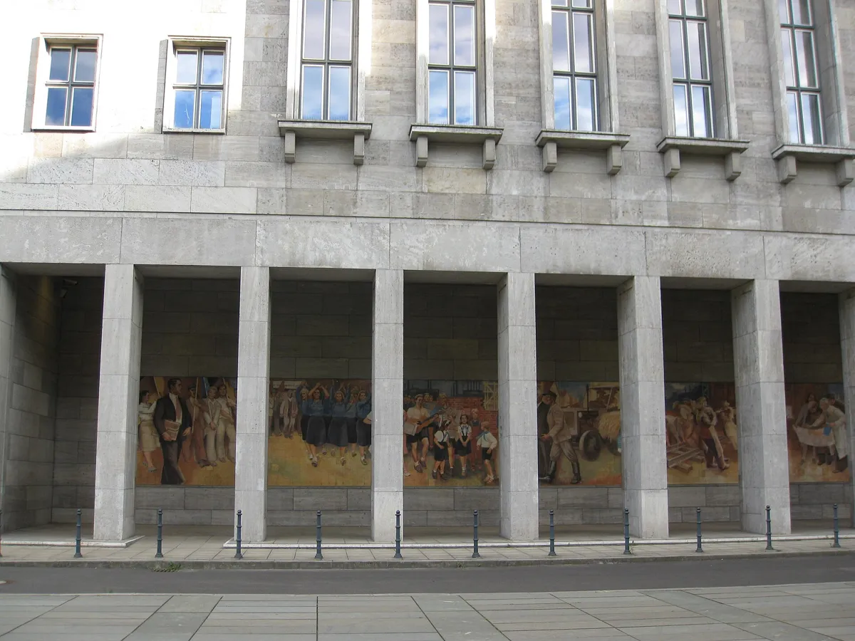
Max Lingner's mural in the colonnade on Leipziger Straße. Photo: bynyalcin, CC BY 3.0, via Wikimedia Commons (resized). Walk east beside the Wall to Wilhelmstraße and turn left. The huge stone building on your left runs all the way to Leipziger Straße. Ernst Sagebiel designed it for Hermann Göring's Air Ministry, built in 1935–36 with more than 2,000 offices. On 7 October 1949 East Germany was founded in its great hall, and it became the "House of Ministries". In that hall on 15 June 1961, the East German leader Walter Ulbricht was asked about a border at the Brandenburg Gate. He answered: "Nobody intends to build a wall." Two months later, building began. At the corner, look into the colonnade: Max Lingner's 24-metre mural of Meissen porcelain tiles shows a happy socialist future, in place of a Nazi relief of marching soldiers. In front of it, under glass in the ground, is the answer: Wolfgang Rüppel's 25-metre photo of workers marching arm in arm on 17 June 1953, when demonstrators gathered outside this building.
More history
Lingner made the mural between 1950 and 1953 and reworked it several times at the request of Ulbricht and prime minister Otto Grotewohl. Rüppel's memorial was unveiled in June 2000. After reunification the Treuhand, which privatised East Germany's state-owned firms, had its headquarters here. Since 1992 the building has carried the name of its president, Detlev Rohwedder, murdered by the Red Army Faction in 1991. The Federal Finance Ministry has been based here since 1999.
Sources: Wikipedia (de), Detlev-Rohwedder-Haus; Wikipedia, Detlev-Rohwedder-Haus; Museum der 1000 Orte (Federal Office for Building), Lingner mural; Museum der 1000 Orte (Federal Office for Building), 17 June memorial; visitBerlin, Memorial to 17 June 1953.
-
Checkpoint Charlie: what is real and what is not
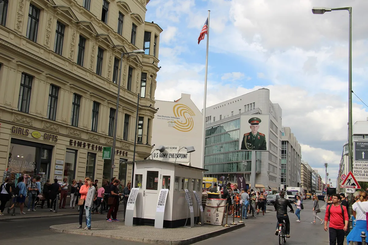
The copy of the first guard hut on Friedrichstraße. Photo: Fred Romero from Paris, France, CC BY 2.0, via Wikimedia Commons (resized). Walk east along Leipziger Straße and turn right into Mauerstraße; the name means Wall Street, but that is an older coincidence. It brings you out on Friedrichstraße at the checkpoint. The Western Allies set it up in August and September 1961 so their soldiers could keep crossing; diplomats and foreigners crossed here too. "Charlie" is the letter C in the radio alphabet. On 27 October 1961 Soviet and American tanks faced each other here, about 100 yards apart, until both sides pulled back the next day. Be clear about what you see. The white hut with sandbags is a copy of the first 1961 hut, unveiled in 2000, and the sandbags are filled with concrete. The last real hut was removed on 22 June 1990 and is now in the AlliiertenMuseum. Costumed "soldiers" charging for photos were banned in 2019. The two giant portraits are Frank Thiel's artwork from 1998, showing real American and Russian soldiers photographed in 1994.
More history
On 17 August 1962, 18-year-old Peter Fechter was shot while climbing the Wall in Zimmerstraße, just east of here. He lay bleeding in the death strip for almost an hour in front of witnesses, and died in hospital. A column at Zimmerstraße 26/27 has marked the place since 1999. The last escape here came on 18 August 1989, when Hans-Peter Spitzner crossed with his daughter in the boot of an Allied car. The Mauermuseum, opened in 1963, and a free open-air exhibition along Friedrichstraße and Zimmerstraße tell more.
Sources: Wikipedia (de), Checkpoint Charlie; Wikipedia, Checkpoint Charlie; Stiftung Berliner Mauer, Frank Thiel's light boxes; Wikipedia (de), Peter Fechter.


_BT_62.jpg)


Practical details
- Terrain
- Flat: Open-Meteo puts every stop between about 32 and 42 m above sea level. Wide pavements and squares, with busy crossings on Ebertstraße and at Potsdamer Platz.
- Step-free
- On the surface the route needs no steps; most of the stairs OpenStreetMap shows near it lead down into stations. It marks Bundestag and Kochstraße stations as wheelchair accessible, though not every entrance is. Thirteen paths through the Holocaust memorial are marked as suitable for wheelchairs.
- Water
- OpenStreetMap lists drinking fountains on Platz des 18. März by stop 2 and near Checkpoint Charlie at the finish.
- Toilets
- OpenStreetMap shows paid toilets at Potsdamer Platz station, by stop 4, and paid toilets about 130 m from the Brandenburg Gate.
- Sit and eat
- Potsdamer Platz (stop 4), at the halfway point, has cafés and places to eat. The tree-lined Tiergarten park is just west of the first three stops.
- Opening hours
- The Holocaust memorial's field is open 24 hours; its Information Centre opens Tuesday to Sunday, 10:00 to 18:00. The Topography of Terror is open daily, 10:00 to 20:00, except 24 and 31 December and 1 January. Both are free. The Reichstag dome is free but needs advance registration and photo ID.
- Shorter walk
- Finish at stop 6, Niederkirchnerstraße: 2.7 km, about an hour. The Topography of Terror points visitors to Potsdamer Platz and Kochstraße U-Bahn stations and Anhalter Bahnhof S-Bahn.
- Getting back
- An entrance to Kochstraße U-Bahn station (U6) is about 100 m south of the checkpoint on Friedrichstraße. Stadtmitte station is about 350 m north.
Walking distances and times from the OSRM foot router on OpenStreetMap data. Elevations from Open-Meteo. Stations, fountains and toilets from OpenStreetMap; opening hours from the Stiftung Denkmal, the Topography of Terror and the German Bundestag. Checked 4 October 2026.
Questions people ask
Can you walk along the Berlin Wall on a self-guided tour?
Yes. This walk follows the Wall's line through the centre: 4 km, 53 minutes of walking and eight stops, about 1½ hours in all, from Bundestag station to Checkpoint Charlie. The map is on this page, and you can print it or save it as a PDF. For a longer walk, the Berlin Wall Trail follows the old border for about 160 km around the former West Berlin.
Where can you still see the Berlin Wall in the centre of Berlin?
On this walk: about 200 m of the original wall on Niederkirchnerstraße, beside the Topography of Terror; segments of the inner wall on Leipziger Platz; and the last round watchtower of its type on Erna-Berger-Straße. Elsewhere, a double row of cobbles in the street marks where the Wall ran.
How long is the walk from the Brandenburg Gate to Checkpoint Charlie?
The direct route is about 1.6 km, roughly 22 minutes on foot. Following this walk's stops between them, past the Holocaust memorial, Potsdamer Platz and Niederkirchnerstraße, it is about 3.1 km and 41 minutes of walking, plus time at each stop.
Is Checkpoint Charlie real?
The place is real: it was the Allied crossing point on Friedrichstraße from 1961 to 1990. The white hut with sandbags is a copy of the first 1961 hut, put up in 2000, and its sandbags are filled with concrete. The last real guard hut was removed on 22 June 1990 and is in the AlliiertenMuseum. The large soldier portraits are a 1998 art installation by Frank Thiel.
Where did the Berlin Wall run in the city centre?
Along the east side of the Reichstag, past the west side of the Brandenburg Gate, across Potsdamer Platz and Leipziger Platz, then along Niederkirchnerstraße and Zimmerstraße to Checkpoint Charlie. In the centre its line is marked by a double row of cobbles with metal strips reading Berliner Mauer 1961–1989.
Walk it with Strolio
Open Strolio by the Reichstag and ask for an hour and a half along the Berlin Wall. Strolio builds walks in any city with mapped streets, so its route may pick different stops from this page. Stories play as you reach each place, and you can ask about anything else you pass, by voice or with a photo. You can also start from your hotel and choose your own time and interests.
More self-guided walks
- All Strolio walks: self-guided walking tours with maps, every fact sourced.
- Madrid's Barrio de las Letras: about an hour, from Lope de Vega's church to the press that printed Don Quixote.
- Barcelona's Gothic Quarter and El Born: about 90 minutes, from Roman columns to the cathedral and El Call.
Sources
- Landesdenkmalamt Berlin, Berlin Wall monuments: Leipziger Platz, Wachturm Erna-Berger-Straße, Niederkirchnerstraße. We used their facts and wrote our own text.
- Stiftung Berliner Mauer (Berlin Wall Foundation), Victims of the Berlin Wall and map of remembrance sites: White Crosses, Brandenburg Gate, Frank Thiel's light boxes; and visitBerlin, Where the Wall used to be
- Wikipedia (German): Berliner Mauer, Berliner Mauerweg, Weiße Kreuze, Reichstagsgebäude, Günter Litfin, Brandenburger Tor, Denkmal für die ermordeten Juden Europas, Führerbunker, Verkehrsturm am Potsdamer Platz, Potsdamer Platz, Niederkirchnerstraße, Topographie des Terrors, Detlev-Rohwedder-Haus, Checkpoint Charlie, Peter Fechter
- Wikipedia (English): Berlin Wall, Brandenburg Gate, Memorial to the Murdered Jews of Europe, Führerbunker, Potsdamer Platz, Detlev-Rohwedder-Haus, Checkpoint Charlie
- Memorials and art: Museum der 1000 Orte, Lingner mural, Museum der 1000 Orte, 17 June 1953 memorial, visitBerlin, Memorial to 17 June 1953
- Opening times and visits: Stiftung Denkmal für die ermordeten Juden Europas, Topography of Terror, German Bundestag, visiting the dome
- Map data and places: © OpenStreetMap contributors, ODbL; walking route from the OSRM foot router run by FOSSGIS
- Elevations: Open-Meteo
- Photos: Wikimedia Commons contributors Dietmar Rabich, T.Voekler, Kurt Kaiser, Marek Śliwecki, OTFW, Pymouss, bynyalcin and Fred Romero, credited under each photo